
Carte topographique Wiston
Cliquez sur la carte pour afficher l’altitude.
À propos de cette carte
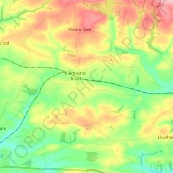
Nom : Carte topographique Wiston, altitude, relief.
Lieu : Wiston, Pembrokeshire, Wales, United Kingdom (51.80522 -4.94133 51.88778 -4.80042)
Altitude moyenne : 77 m
Altitude minimum : 7 m
Altitude maximum : 175 m
Autres cartes topographiques
Cliquez sur une carte pour visualiser sa topographie, son altitude et son relief.
Preseli Mountains
United Kingdom > Wales > Pembrokeshire > Puncheston
Samuel Lewis's A Topographical Dictionary of Wales published in 1833 said of Maenclochog parish.
Altitude moyenne : 217 m
Caldey Island
United Kingdom > Wales > Pembrokeshire
Caldey Island is about 1.5 miles (2.4 km) long and 1 mile (1.6 km) in width at its widest. It has an area of 538 acres (2.18 km2) and its highest elevation is 197 feet (60 m). The island lies in Carmarthen Bay on the northern side of the Bristol Channel in the county of Pembrokeshire, a little over 2.5 miles…
Altitude moyenne : 5 m
Square and Compass
United Kingdom > Wales > Pembrokeshire > St Davids > Square and Compass
Altitude moyenne : 91 m
Walton West
United Kingdom > Wales > Pembrokeshire > Broad Haven > Walton West
Altitude moyenne : 45 m