
Carte topographique Puncheston
Cliquez sur la carte pour afficher l’altitude.
Puncheston
A map of 1578 shows the parish as Castle Male, presumably a phonetic spelling of the Welsh name by the English mapmaker. Lewis's Topographical Dictionary of 1844 gives 326 inhabitants (the 1849 edition gives 255) for the parish, which includes the village and a number of outlying residences and farms. Lewis surmises that the original name was Castell Mael, deriving from an ancient encampment of which there are remains. A railway passed through the parish in the 19th and 20th centuries, with a halt at the village.
À propos de cette carte
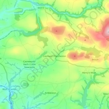
Nom : Carte topographique Puncheston, altitude, relief.
Lieu : Puncheston, Pembrokeshire, Wales, United Kingdom (51.90302 -4.96180 51.96009 -4.79285)
Altitude moyenne : 165 m
Altitude minimum : 28 m
Altitude maximum : 465 m
Autres cartes topographiques
Cliquez sur une carte pour visualiser sa topographie, son altitude et son relief.
Preseli Mountains
United Kingdom > Wales > Pembrokeshire > Puncheston
Samuel Lewis's A Topographical Dictionary of Wales published in 1833 said of Maenclochog parish.
Altitude moyenne : 217 m
Caldey Island
United Kingdom > Wales > Pembrokeshire
Caldey Island is about 1.5 miles (2.4 km) long and 1 mile (1.6 km) in width at its widest. It has an area of 538 acres (2.18 km2) and its highest elevation is 197 feet (60 m). The island lies in Carmarthen Bay on the northern side of the Bristol Channel in the county of Pembrokeshire, a little over 2.5 miles…
Altitude moyenne : 5 m
Square and Compass
United Kingdom > Wales > Pembrokeshire > St Davids > Square and Compass
Altitude moyenne : 91 m
Walton West
United Kingdom > Wales > Pembrokeshire > Broad Haven > Walton West
Altitude moyenne : 45 m