
Carte topographique Munich
Carte interactive
Cliquez sur la carte pour afficher l’altitude.
À propos de cette carte
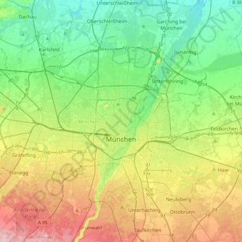
Nom : Carte topographique Munich, altitude, relief.
Lieu : Munich, Bavaria, Germany (48.06162 11.36078 48.24812 11.72291)
Altitude moyenne : 524 m
Altitude minimum : 466 m
Altitude maximum : 633 m
Munich lies on the elevated plains of Upper Bavaria, about 50 km (31 mi) north of the northern edge of the Alps, at an altitude of about 520 m (1,706 ft) ASL. The local rivers are the Isar and the Würm. Munich is situated in the Northern Alpine Foreland. The northern part of this sandy plateau includes a highly fertile flint area which is no longer affected by the folding processes found in the Alps, while the southern part is covered with morainic hills. Between these are fields of fluvio-glacial out-wash, such as around Munich. Wherever these deposits get thinner, the ground water can permeate the gravel surface and flood the area, leading to marshes as in the north of Munich.
Autres cartes topographiques
Cliquez sur une carte pour visualiser sa topographie, son altitude et son relief.
93105
Germany > Bavaria > Landkreis Regensburg > Tegernheim
93105, Tegernheim, Landkreis Regensburg, Bavaria, Germany
Altitude moyenne : 380 m
Pegnitz
Germany > Bavaria > Landkreis Bayreuth
Pegnitz, Landkreis Bayreuth, Bavaria, 91257, Germany
Altitude moyenne : 485 m
Rubi
Germany > Bavaria > Landkreis Oberallgäu > Oberstdorf
Rubi, Oberstdorf, Landkreis Oberallgäu, Bavaria, 87561, Germany
Altitude moyenne : 973 m
Garmisch-Partenkirchen
Germany > Bavaria > Landkreis Garmisch-Partenkirchen
Garmisch-Partenkirchen, Landkreis Garmisch-Partenkirchen, Bavaria, Germany
Altitude moyenne : 1’326 m
Tiefenbach
Germany > Bavaria > Landkreis Rosenheim > Nußdorf am Inn
Tiefenbach, Nußdorf am Inn, Landkreis Rosenheim, Bavaria, 83131, Germany
Altitude moyenne : 484 m
Ramsau bei Berchtesgaden
Germany > Bavaria > Landkreis Berchtesgadener Land
Ramsau bei Berchtesgaden, Landkreis Berchtesgadener Land, Bavaria, 83486, Germany
Altitude moyenne : 1’302 m
Wind
Germany > Bavaria > Landkreis Bamberg
Wind, Pommersfelden, Landkreis Bamberg, Bavaria, 96178, Germany
Altitude moyenne : 284 m
Rain
Germany > Bavaria > Landkreis Donau-Ries
Rain, Rain (Schwaben), Landkreis Donau-Ries, Bavaria, 86641, Germany
Altitude moyenne : 414 m
Horn
Germany > Bavaria > Ansbach (district) > Leutershausen
Horn, Leutershausen, Ansbach (district), Bavaria, 91578, Germany
Altitude moyenne : 471 m
Neuburg-Schrobenhausen
Neuburg-Schrobenhausen, Bavaria, 86562, Germany
Altitude moyenne : 483 m
Bad Aibling
Germany > Bavaria > Landkreis Rosenheim
Bad Aibling, Landkreis Rosenheim, Bavaria, 83043, Germany
Altitude moyenne : 488 m
Obertrubach
Germany > Bavaria > Landkreis Forchheim
Obertrubach, Landkreis Forchheim, Bavaria, 91286, Germany
Altitude moyenne : 518 m
Pressath
Germany > Bavaria > Landkreis Neustadt an der Waldnaab
Pressath, Pressath (VGem), Landkreis Neustadt an der Waldnaab, Bavaria, 92690, Germany
Altitude moyenne : 470 m
Stein
Germany > Bavaria > Fürth (district)
Stein, Fürth (district), Bavaria, 90547, Germany
Altitude moyenne : 326 m
Betzenstein
Germany > Bavaria > Landkreis Bayreuth
Betzenstein, Betzenstein (VGem), Landkreis Bayreuth, Bavaria, 91282, Germany
Altitude moyenne : 501 m
Seubersdorf in der Oberpfalz
Germany > Bavaria > Landkreis Neumarkt in der Oberpfalz
Seubersdorf in der Oberpfalz, Landkreis Neumarkt in der Oberpfalz, Bavaria, 92358, Germany
Altitude moyenne : 519 m
Lindberg
Germany > Bavaria > Landkreis Regen
Lindberg, Landkreis Regen, Bavaria, Germany
Altitude moyenne : 809 m
Ellensberg
Germany > Bavaria > Landkreis Weilheim-Schongau > Bernbeuren
Ellensberg, Bernbeuren, Bernbeuren (VGem), Landkreis Weilheim-Schongau, Bavaria, 86975, Germany
Altitude moyenne : 822 m
Rehau
Germany > Bavaria > Landkreis Hof
Rehau, Landkreis Hof, Bavaria, 95111, Germany
Altitude moyenne : 575 m
Nördlingen
Germany > Bavaria > Landkreis Donau-Ries
Nördlingen, Landkreis Donau-Ries, Bavaria, Germany
Altitude moyenne : 453 m
Blindheim
Germany > Bavaria > Landkreis Dillingen an der Donau
Blindheim, Höchstädt an der Donau (VGem), Landkreis Dillingen an der Donau, Bavaria, 89434, Germany
Altitude moyenne : 434 m
Watzmann
Germany > Bavaria > Landkreis Berchtesgadener Land > Ramsau bei Berchtesgaden
Watzmann, Ramsau bei Berchtesgaden, Landkreis Berchtesgadener Land, Bavaria, Germany
Altitude moyenne : 1’177 m
Kempten (Allgäu)
Germany > Bavaria > Kempten (Allgäu)
Kempten (Allgäu), Bavaria, Germany
Altitude moyenne : 737 m
Murnau am Staffelsee
Germany > Bavaria > Landkreis Garmisch-Partenkirchen > Murnau am Staffelsee
Murnau am Staffelsee, Landkreis Garmisch-Partenkirchen, Bavaria, 82418, Germany
Altitude moyenne : 670 m
Türkheim
Germany > Bavaria > Landkreis Unterallgäu > Türkheim
Türkheim, Verwaltungsgemeinschaft Türkheim, Landkreis Unterallgäu, Bavaria, 86842, Germany
Altitude moyenne : 603 m
Unterhaching
Germany > Bavaria > Landkreis München > Unterhaching
Unterhaching, Landkreis München, Bavaria, 82008, Germany
Altitude moyenne : 556 m
Zenting
Germany > Bavaria > Landkreis Freyung-Grafenau > Zenting
Zenting, Thurmansbang (VGem), Landkreis Freyung-Grafenau, Bavaria, 94579, Germany
Altitude moyenne : 550 m
Ingolstadt
Germany > Bavaria > Ingolstadt > Ingolstadt
Ingolstadt, Bavaria, 85057, Germany
Altitude moyenne : 409 m
Eitensheim
Germany > Bavaria > Landkreis Eichstätt > Eitensheim
Eitensheim, Eitensheim (VGem), Landkreis Eichstätt, Bavaria, 85117, Germany
Altitude moyenne : 421 m
Markt Schwaben
Germany > Bavaria > Landkreis Ebersberg > Markt Schwaben > Markt Schwaben
Markt Schwaben, Landkreis Ebersberg, Bavaria, 85570, Germany
Altitude moyenne : 513 m
Am Berg
Germany > Bavaria > Landkreis Schwandorf > Neunburg vorm Wald
Am Berg, Neunburg vorm Wald, Landkreis Schwandorf, Bavaria, 92540, Germany
Altitude moyenne : 445 m
Kleinberg
Germany > Bavaria > Landkreis Neustadt an der Waldnaab > Kirchendemenreuth
Kleinberg, Kirchendemenreuth, Neustadt an der Waldnaab (VGem), Landkreis Neustadt an der Waldnaab, Bavaria, 92660, Germany
Altitude moyenne : 471 m
Füssen
Germany > Bavaria > Landkreis Ostallgäu > Füssen
Füssen, Landkreis Ostallgäu, Bavaria, 87629, Germany
Altitude moyenne : 852 m
Neukirchen
Germany > Bavaria > Eglharting > Neukirchen
Neukirchen, Eglharting, Kirchseeon, Landkreis Ebersberg, Bavaria, 85604, Germany
Altitude moyenne : 559 m
Horn
Germany > Bavaria > Leutershausen
Horn, Leutershausen, Ansbach (district), Bavaria, 91578, Germany
Altitude moyenne : 474 m
Burglengenfeld
Germany > Bavaria > Burglengenfeld
Burglengenfeld, Landkreis Schwandorf, Upper Palatinate, Bavaria, 93133, Germany
Altitude moyenne : 400 m
Lake Starnberg
Lake Starnberg, Südliche Seestraße, Ammerland, Münsing, Landkreis Bad Tölz-Wolfratshausen, Upper Bavaria, Bavaria, 82541, Germany
Altitude moyenne : 639 m
Drei Zinnen
Germany > Bavaria > Hiltpoltstein
Drei Zinnen, Hiltpoltstein, Gräfenberg (VGem), Landkreis Forchheim, Bavaria, 91355, Germany
Altitude moyenne : 463 m