
Carte topographique Garmisch-Partenkirchen
Carte interactive
Cliquez sur la carte pour afficher l’altitude.
À propos de cette carte
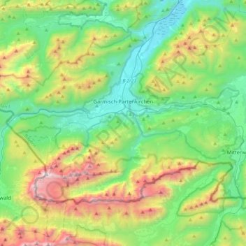
Nom : Carte topographique Garmisch-Partenkirchen, altitude, relief.
Altitude moyenne : 1’326 m
Altitude minimum : 633 m
Altitude maximum : 2’945 m
Garmisch-Partenkirchen leans towards an oceanic climate, and its winters are colder than the rest of Bavaria. Due to its higher elevation, it is very close to the winters associated with continental climates; it has a relatively wet and snowy climate, with high precipitation year-round. As of 2013 the regions in the west and east of the town were cited as having highest numbers of thunderstorm days in Europe.
Autres cartes topographiques
Cliquez sur une carte pour visualiser sa topographie, son altitude et son relief.
Murnau am Staffelsee
Germany > Bavaria > Landkreis Garmisch-Partenkirchen > Murnau am Staffelsee
Murnau am Staffelsee, Landkreis Garmisch-Partenkirchen, Bavaria, 82418, Germany
Altitude moyenne : 670 m