
Carte topographique Spaulding
Carte interactive
Cliquez sur la carte pour afficher l’altitude.
À propos de cette carte
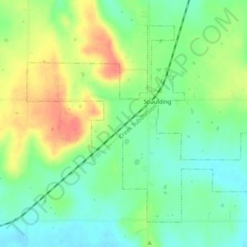
Nom : Carte topographique Spaulding, altitude, relief.
Lieu : Spaulding, Hughes County, Oklahoma, United States (34.99949 -96.45915 35.02309 -96.42302)
Altitude moyenne : 251 m
Altitude minimum : 227 m
Altitude maximum : 286 m
Autres cartes topographiques
Cliquez sur une carte pour visualiser sa topographie, son altitude et son relief.
Calvin
United States > Oklahoma > Hughes County
Calvin, Hughes County, Oklahoma, 74531, United States
Altitude moyenne : 232 m
Wetumka
United States > Oklahoma > Hughes County
Wetumka, Hughes County, Oklahoma, 74883, United States
Altitude moyenne : 235 m
Gerty
United States > Oklahoma > Hughes County
Gerty, Hughes County, Oklahoma, United States
Altitude moyenne : 258 m
Atwood
United States > Oklahoma > Hughes County
Atwood, Hughes County, Oklahoma, United States
Altitude moyenne : 243 m
Yeager
United States > Oklahoma > Hughes County
Yeager, Hughes County, Oklahoma, United States
Altitude moyenne : 245 m
Dustin
United States > Oklahoma > Hughes County
Dustin, Hughes County, Oklahoma, 74839, United States
Altitude moyenne : 217 m
Horntown
United States > Oklahoma > Hughes County
Horntown, Hughes County, Oklahoma, United States
Altitude moyenne : 255 m
Lamar
United States > Oklahoma > Hughes County
Lamar, Hughes County, Oklahoma, 74850, United States
Altitude moyenne : 259 m
Stuart
United States > Oklahoma > Hughes County
Stuart, Hughes County, Oklahoma, United States
Altitude moyenne : 229 m
Holdenville
United States > Oklahoma > Hughes County
Holdenville, Hughes County, Oklahoma, 74848, United States
Altitude moyenne : 263 m