
Carte topographique Yeager
Carte interactive
Cliquez sur la carte pour afficher l’altitude.
À propos de cette carte
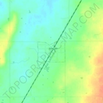
Nom : Carte topographique Yeager, altitude, relief.
Lieu : Yeager, Hughes County, Oklahoma, United States (35.15402 -96.34444 35.15957 -96.33567)
Altitude moyenne : 245 m
Altitude minimum : 229 m
Altitude maximum : 268 m
The town lies at an elevation of 870 feet above sea level and has an average of 39 inches of rain and 6.1 inches of snowfall annually.
Autres cartes topographiques
Cliquez sur une carte pour visualiser sa topographie, son altitude et son relief.
Calvin
United States > Oklahoma > Hughes County
Calvin, Hughes County, Oklahoma, 74531, United States
Altitude moyenne : 232 m
Wetumka
United States > Oklahoma > Hughes County
Wetumka, Hughes County, Oklahoma, 74883, United States
Altitude moyenne : 235 m
Atwood
United States > Oklahoma > Hughes County
Atwood, Hughes County, Oklahoma, United States
Altitude moyenne : 243 m
Gerty
United States > Oklahoma > Hughes County
Gerty, Hughes County, Oklahoma, United States
Altitude moyenne : 258 m
Spaulding
United States > Oklahoma > Hughes County
Spaulding, Hughes County, Oklahoma, United States
Altitude moyenne : 251 m
Dustin
United States > Oklahoma > Hughes County
Dustin, Hughes County, Oklahoma, 74839, United States
Altitude moyenne : 217 m
Horntown
United States > Oklahoma > Hughes County
Horntown, Hughes County, Oklahoma, United States
Altitude moyenne : 255 m
Lamar
United States > Oklahoma > Hughes County
Lamar, Hughes County, Oklahoma, 74850, United States
Altitude moyenne : 259 m
Stuart
United States > Oklahoma > Hughes County
Stuart, Hughes County, Oklahoma, United States
Altitude moyenne : 229 m
Holdenville
United States > Oklahoma > Hughes County
Holdenville, Hughes County, Oklahoma, 74848, United States
Altitude moyenne : 263 m