
Carte topographique New South Wales
Carte interactive
Cliquez sur la carte pour afficher l’altitude.
À propos de cette carte
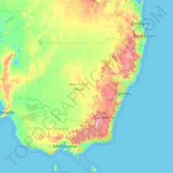
Nom : Carte topographique New South Wales, altitude, relief.
Lieu : New South Wales, Australia (-37.52801 140.99926 -28.14153 159.33903)
Altitude moyenne : 154 m
Altitude minimum : -6 m
Altitude maximum : 2’129 m
The climate in the southern half of the state is generally warm to hot in summer and cool in the winter. The seasons are more defined in the southern half of the state, especially as one moves inland towards South West Slopes, Central West and the Riverina region. The climate in the northeast region of the state, or the North Coast, bordering Queensland, is hot and humid in the summer and mild in winter. The Northern Tablelands, which are also on the North coast, have relatively mild summers and cold winters, due to their high elevation on the Great Dividing Range.
Autres cartes topographiques
Cliquez sur une carte pour visualiser sa topographie, son altitude et son relief.
Mount Sunderland
Australia > South Australia > Pastoral Unincorporated Area
Mount Sunderland, Pastoral Unincorporated Area, South Australia, Australia
Altitude moyenne : 682 m
Northcote District
Australia > Victoria > Melbourne
Northcote District, Melbourne, City of Darebin, Victoria, Australia
Altitude moyenne : 44 m
Sydney
Sydney, Council of the City of Sydney, New South Wales, Australia
Altitude moyenne : 53 m
Womblebank
Womblebank, Maranoa Regional, Queensland, Australia
Altitude moyenne : 557 m
Southern Moreton Bay Islands
Australia > Queensland > Gold Coast City
Southern Moreton Bay Islands, Gold Coast City, Queensland, Australia
Altitude moyenne : 4 m
Melacca Swamp Conservation Area
Australia > Litchfield Municipality
Melacca Swamp Conservation Area, Koolpinyah, Litchfield Municipality, Northern Territory, Australia
Altitude moyenne : 7 m
White Bay
Australia > New South Wales > Sydney
White Bay, Sydney, New South Wales, 2041, Australia
Altitude moyenne : 14 m
Beechworth
Beechworth, Shire of Indigo, Victoria, 3747, Australia
Altitude moyenne : 484 m
Elizabeth Town
Elizabeth Town, Meander Valley, Tasmania, 7304, Australia
Altitude moyenne : 214 m
Red Cliffs
Red Cliffs, Rural City of Mildura, Victoria, 3496, Australia
Altitude moyenne : 51 m
Palm Island
Palm Island, Palm Island Aboriginal Shire, Queensland, Australia
Altitude moyenne : 7 m
Torres Strait
Torres Strait, Torres Shire, Queensland, Australia
Altitude moyenne : 0 m
Cronulla Beach
Australia > New South Wales > Sydney
Cronulla Beach, Cronulla, Sutherland Shire, Sydney, Sutherland Shire Council, New South Wales, 2230, Australia
Altitude moyenne : 9 m
Wakki Beach
Australia > New South Wales > Scotts Head
Wakki Beach, Scotts Head, Nambucca Valley Council, New South Wales, 2447, Australia
Altitude moyenne : 7 m
Wanda Beach
Australia > New South Wales > Sydney
Wanda Beach, Cronulla, Sutherland Shire, Sydney, Sutherland Shire Council, New South Wales, 2230, Australia
Altitude moyenne : 5 m
Lake Eucumbene
Australia > New South Wales > Anglers Reach
Lake Eucumbene, Anglers Reach, Snowy Monaro Regional Council, New South Wales, 2629, Australia
Altitude moyenne : 1’261 m
Elouera Beach
Australia > New South Wales > Sydney
Elouera Beach, Cronulla, Sutherland Shire, Sydney, Sutherland Shire Council, New South Wales, 2230, Australia
Altitude moyenne : 6 m
North Cronulla Beach
Australia > New South Wales > Sydney
North Cronulla Beach, Cronulla, Sutherland Shire, Sydney, Sutherland Shire Council, New South Wales, 2230, Australia
Altitude moyenne : 8 m
Flood Hill
Flood Hill, West Daly Region, Northern Territory, Australia
Altitude moyenne : 83 m
Cronulla Sand Dunes
Australia > New South Wales > Sydney
Cronulla Sand Dunes, Kurnell, Sutherland Shire, Sydney, Sutherland Shire Council, New South Wales, 2231, Australia
Altitude moyenne : 5 m
Ruby Creek
Ruby Creek, Tenterfield Shire Council, New South Wales, 4380, Australia
Altitude moyenne : 893 m
Ningaloo Australian Marine Park
Ningaloo Australian Marine Park, Western Australia, Australia
Altitude moyenne : 17 m
King Edward Park
Australia > New South Wales > Newcastle
King Edward Park, Newcastle, Newcastle-Maitland, Newcastle City Council, New South Wales, 2300, Australia
Altitude moyenne : 8 m
Greenbank
Greenbank, Greater Brisbane, Queensland, 4124, Australia
Altitude moyenne : 62 m
Great Keppel Island
Great Keppel Island, The Keppels, Livingstone Shire, Queensland, Australia
Altitude moyenne : 12 m
Warranwood
Australia > Victoria > Melbourne
Warranwood, Melbourne, City of Maroondah, Victoria, 3134, Australia
Altitude moyenne : 131 m
Lake St Clair
Lake St Clair, Central Highlands, Tasmania, Australia
Altitude moyenne : 909 m
Central Tilba
Central Tilba, Eurobodalla Shire Council, New South Wales, 2546, Australia
Altitude moyenne : 107 m
Brenda Park
Australia > South Australia > Mid Murray Council
Brenda Park, Mid Murray Council, South Australia, 5320, Australia
Altitude moyenne : 23 m
Rozelle
Australia > New South Wales > Sydney
Rozelle, Inner West, Sydney, Inner West Council, New South Wales, 2039, Australia
Altitude moyenne : 16 m
Howes Valley
Howes Valley, Singleton Council, New South Wales, 2330, Australia
Altitude moyenne : 311 m
Lake Louise
Lake Louise, Grindelwald, West Tamar, Tasmania, Australia
Altitude moyenne : 124 m
Camden Council
Camden Council, New South Wales, Australia
Altitude moyenne : 90 m
Seahampton
Australia > New South Wales > Newcastle-Maitland
Seahampton, Newcastle-Maitland, Lake Macquarie City Council, New South Wales, 2286, Australia
Altitude moyenne : 74 m
Jurien Bay
Jurien Bay, Shire Of Dandaragan, Western Australia, 6516, Australia
Altitude moyenne : 45 m
Cape Gloucester
Cape Gloucester, Whitsunday Regional, Queensland, Australia
Altitude moyenne : 44 m
Strathpine
Strathpine, Greater Brisbane, City of Moreton Bay, Queensland, 4500, Australia
Altitude moyenne : 13 m
Bullaburra
Australia > New South Wales > Sydney
Bullaburra, Sydney, Blue Mountains City Council, New South Wales, 2784, Australia
Altitude moyenne : 712 m
Geebung
Australia > Queensland > Brisbane City
Geebung, Brisbane City, Queensland, Australia
Altitude moyenne : 18 m
Hurstville
Australia > New South Wales > Sydney
Hurstville, St George, Sydney, Georges River Council, New South Wales, 2220, Australia
Altitude moyenne : 50 m
Spring Mountain
Spring Mountain, Inverell Shire Council, New South Wales, 2360, Australia
Altitude moyenne : 990 m
Tennant Creek
Tennant Creek, Barkly Region, Northern Territory, Australia
Altitude moyenne : 366 m
Lord Howe Island
Lord Howe Island, New South Wales, 2898, Australia
Altitude moyenne : 27 m
Belair National Park
Australia > South Australia > Adelaide
Belair National Park, Mulara Track, Belair, Adelaide, City of Mitcham, South Australia, 5052, Australia
Altitude moyenne : 386 m
Laura
Laura, Northern Areas Council, South Australia, 5480, Australia
Altitude moyenne : 300 m