
Carte topographique Tasmania
Carte interactive
Cliquez sur la carte pour afficher l’altitude.
À propos de cette carte
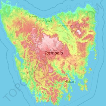
Nom : Carte topographique Tasmania, altitude, relief.
Lieu : Tasmania, Australia (-43.64304 144.60734 -40.64139 148.35910)
Altitude moyenne : 220 m
Altitude minimum : -3 m
Altitude maximum : 1’524 m
The most mountainous region is the Central Highlands area, which covers most of the central western parts of the state. The Midlands located in the central east, is fairly flat, and is predominantly used for agriculture, although farming activity is scattered throughout the state. Tasmania's tallest mountain is Mount Ossa at 1,617 m (5,305 ft). Much of Tasmania is still densely forested, with the Southwest National Park and neighbouring areas holding some of the last temperate rain forests in the Southern Hemisphere. The Tarkine, containing Savage River National Park located in the island's far north west, is the largest temperate rainforest area in Australia covering about 3,800 square kilometres (1,500 sq mi). With its rugged topography, Tasmania has a great number of rivers. Several of Tasmania's largest rivers have been dammed at some point to provide hydroelectricity. Many rivers begin in the Central Highlands and flow out to the coast. Tasmania's major population centres are mainly situated around estuaries (some of which are named rivers).
Autres cartes topographiques
Cliquez sur une carte pour visualiser sa topographie, son altitude et son relief.
Elizabeth Town
Elizabeth Town, Meander Valley, Tasmania, 7304, Australia
Altitude moyenne : 214 m
Lake St Clair
Lake St Clair, Central Highlands, Tasmania, Australia
Altitude moyenne : 909 m
Lake Louise
Lake Louise, Grindelwald, West Tamar, Tasmania, Australia
Altitude moyenne : 124 m
Garden Island
Garden Island, Huon Valley, Tasmania, Australia
Altitude moyenne : 9 m
Mole Creek
Mole Creek, Meander Valley, Tasmania, 7304, Australia
Altitude moyenne : 440 m
Launceston
Launceston, City of Launceston, Tasmania, Australia
Altitude moyenne : 194 m
Mount Field
Mount Field, Derwent Valley, Tasmania, 7140, Australia
Altitude moyenne : 720 m
Lake Margaret
Australia > Tasmania > Lake Margaret
Lake Margaret, West Coast, Tasmania, Australia
Altitude moyenne : 761 m
Bream Creek
Australia > Tasmania > Bream Creek
Bream Creek, Sorell, Tasmania, Australia
Altitude moyenne : 35 m
Cradle Mountain
Cradle Mountain, Kentish, Tasmania, Australia
Altitude moyenne : 760 m
Binalong Bay
Binalong Bay, Break O'Day, Tasmania, Australia
Altitude moyenne : 31 m
Great Lake
Great Lake, Central Highlands, Tasmania, Australia
Altitude moyenne : 1’095 m
Strathgordon
Strathgordon, Derwent Valley, Tasmania, 7139, Australia
Altitude moyenne : 388 m
North Scottsdale
North Scottsdale, Dorset, Tasmania, 7260, Australia
Altitude moyenne : 103 m
Prospect Vale
Australia > Tasmania > Launceston
Prospect Vale, Launceston, Meander Valley, Tasmania, 7250, Australia
Altitude moyenne : 174 m
Mount Tyndall
Mount Tyndall, West Coast, Tasmania, Australia
Altitude moyenne : 910 m
Beauty Point
Beauty Point, West Tamar, Tasmania, Australia
Altitude moyenne : 20 m
West Gawler River
Australia > Tasmania > Sprent > Gawler
West Gawler River, Gawler, Sprent, Central Coast, Tasmania, Australia
Altitude moyenne : 201 m
Wellington Park
Wellington Park, Derwent Valley, Tasmania, 7054, Australia
Altitude moyenne : 419 m
Mount Ossa
Mount Ossa, Meander Valley, Tasmania, Australia
Altitude moyenne : 1’218 m
Walls Of Jerusalem
Walls Of Jerusalem, Tasmania, Australia
Altitude moyenne : 1’284 m
Roger River
Australia > Tasmania > Roger River
Roger River, Circular Head, Tasmania, Australia
Altitude moyenne : 131 m
Goose Island
Goose Island, Flinders Council, Tasmania, Australia
Altitude moyenne : 1 m