
Faire un don
Équipez-vous pour votre prochaine aventure :
En tant que Partenaire Amazon, ce site perçoit une commission sur les achats éligibles sans surcoût pour vous.
Carte topographique Wraysbury
Cliquez sur la carte pour afficher l’altitude.
Faire un don
Équipez-vous pour votre prochaine aventure :
En tant que Partenaire Amazon, ce site perçoit une commission sur les achats éligibles sans surcoût pour vous.
Wraysbury
The new chapel, with its elegant slender tower, was opened on 16 October 1862; the building works had cost around £800. The striking terracotta relief panel, The City of Refuge, on the front elevation of the chapel, was created by the renowned Doulton & Co artist George Tinworth and is signed with his monogram. After Buckland's death, James Doulton, his son-in-law and a cousin of Sir Henry Doulton, took over the preaching duties. Later James' son-in-law the Reverend Arthur Gostick Shorrock took over the duties. Arthur had been a student preacher in Wraysbury in the 1880s, after which he spent 35 years as a missionary in Shaanxi, China.
Faire un don
Équipez-vous pour votre prochaine aventure :
En tant que Partenaire Amazon, ce site perçoit une commission sur les achats éligibles sans surcoût pour vous.
À propos de cette carte
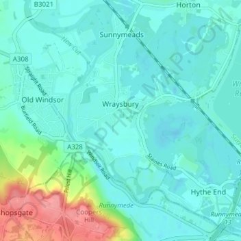
Nom : Carte topographique Wraysbury, altitude, relief.
Altitude moyenne : 26 m
Altitude minimum : 10 m
Altitude maximum : 90 m
Faire un don
Équipez-vous pour votre prochaine aventure :
En tant que Partenaire Amazon, ce site perçoit une commission sur les achats éligibles sans surcoût pour vous.
Autres cartes topographiques
Cliquez sur une carte pour visualiser sa topographie, son altitude et son relief.
Windsor Marina
United Kingdom > England > Royal Borough of Windsor and Maidenhead > Oakley Green
Altitude moyenne : 26 m
Silwood Park
United Kingdom > England > Royal Borough of Windsor and Maidenhead > Beggar's Bush
Altitude moyenne : 61 m
Faire un don
Équipez-vous pour votre prochaine aventure :
En tant que Partenaire Amazon, ce site perçoit une commission sur les achats éligibles sans surcoût pour vous.
Braywoodside
United Kingdom > England > Royal Borough of Windsor and Maidenhead
Altitude moyenne : 43 m
Sunninghill
United Kingdom > England > Royal Borough of Windsor and Maidenhead
Altitude moyenne : 67 m
Cookham Rise
United Kingdom > England > Royal Borough of Windsor and Maidenhead
Altitude moyenne : 44 m
Faire un don
Équipez-vous pour votre prochaine aventure :
En tant que Partenaire Amazon, ce site perçoit une commission sur les achats éligibles sans surcoût pour vous.
Magna Carta Island
United Kingdom > England > Royal Borough of Windsor and Maidenhead > Wraysbury
Altitude moyenne : 32 m
Cookham Dean
United Kingdom > England > Royal Borough of Windsor and Maidenhead
Altitude moyenne : 50 m
Bridge Gardens
United Kingdom > England > Royal Borough of Windsor and Maidenhead > Maidenhead
Altitude moyenne : 30 m
Upton Court Park
United Kingdom > England > Royal Borough of Windsor and Maidenhead > Slough
Altitude moyenne : 23 m
Faire un don
Équipez-vous pour votre prochaine aventure :
En tant que Partenaire Amazon, ce site perçoit une commission sur les achats éligibles sans surcoût pour vous.
Formosa Island
United Kingdom > England > Royal Borough of Windsor and Maidenhead > Cookham
Altitude moyenne : 48 m
Burchett's Green
United Kingdom > England > Royal Borough of Windsor and Maidenhead > Hurley
Altitude moyenne : 68 m
Faire un don
Équipez-vous pour votre prochaine aventure :
En tant que Partenaire Amazon, ce site perçoit une commission sur les achats éligibles sans surcoût pour vous.
Windsor Castle
United Kingdom > England > Royal Borough of Windsor and Maidenhead > Windsor > Clewer Village
Altitude moyenne : 23 m
Oakley Green
United Kingdom > England > Royal Borough of Windsor and Maidenhead
Altitude moyenne : 37 m
Faire un don
Équipez-vous pour votre prochaine aventure :
En tant que Partenaire Amazon, ce site perçoit une commission sur les achats éligibles sans surcoût pour vous.
Windsor Castle
United Kingdom > England > Royal Borough of Windsor and Maidenhead > Windsor > Clewer Village
Altitude moyenne : 23 m
Sunninghill
United Kingdom > England > Royal Borough of Windsor and Maidenhead
Altitude moyenne : 67 m
Windsor Castle
United Kingdom > England > Royal Borough of Windsor and Maidenhead > Windsor > Clewer Village
Altitude moyenne : 23 m
Faire un don
Équipez-vous pour votre prochaine aventure :
En tant que Partenaire Amazon, ce site perçoit une commission sur les achats éligibles sans surcoût pour vous.
Cookham Dean
United Kingdom > England > Royal Borough of Windsor and Maidenhead
Altitude moyenne : 50 m
Cookham Rise
United Kingdom > England > Royal Borough of Windsor and Maidenhead
Altitude moyenne : 44 m
Faire un don
Équipez-vous pour votre prochaine aventure :
En tant que Partenaire Amazon, ce site perçoit une commission sur les achats éligibles sans surcoût pour vous.
Windsor Castle
United Kingdom > England > Royal Borough of Windsor and Maidenhead > Windsor > Clewer Village
Altitude moyenne : 23 m