
Faire un don
Équipez-vous pour votre prochaine aventure :
En tant que Partenaire Amazon, ce site perçoit une commission sur les achats éligibles sans surcoût pour vous.
Carte topographique Cookham Rise
Cliquez sur la carte pour afficher l’altitude.
Faire un don
Équipez-vous pour votre prochaine aventure :
En tant que Partenaire Amazon, ce site perçoit une commission sur les achats éligibles sans surcoût pour vous.
À propos de cette carte
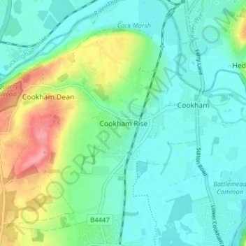
Nom : Carte topographique Cookham Rise, altitude, relief.
Altitude moyenne : 44 m
Altitude minimum : 19 m
Altitude maximum : 109 m
Faire un don
Équipez-vous pour votre prochaine aventure :
En tant que Partenaire Amazon, ce site perçoit une commission sur les achats éligibles sans surcoût pour vous.
Autres cartes topographiques
Cliquez sur une carte pour visualiser sa topographie, son altitude et son relief.
Windsor Marina
United Kingdom > England > Royal Borough of Windsor and Maidenhead > Oakley Green
Altitude moyenne : 26 m
Sunningdale
United Kingdom > England > Royal Borough of Windsor and Maidenhead
Altitude moyenne : 61 m
Faire un don
Équipez-vous pour votre prochaine aventure :
En tant que Partenaire Amazon, ce site perçoit une commission sur les achats éligibles sans surcoût pour vous.
Wraysbury
United Kingdom > England > Royal Borough of Windsor and Maidenhead
The new chapel, with its elegant slender tower, was opened on 16 October 1862; the building works had cost around £800. The striking terracotta relief panel, The City of Refuge, on the front elevation of the chapel, was created by the renowned Doulton & Co artist George Tinworth and is signed with his…
Altitude moyenne : 25 m
White Waltham
United Kingdom > England > Royal Borough of Windsor and Maidenhead
Altitude moyenne : 41 m
Shottesbrooke
United Kingdom > England > Royal Borough of Windsor and Maidenhead
Altitude moyenne : 41 m
Faire un don
Équipez-vous pour votre prochaine aventure :
En tant que Partenaire Amazon, ce site perçoit une commission sur les achats éligibles sans surcoût pour vous.
Magna Carta Island
United Kingdom > England > Royal Borough of Windsor and Maidenhead > Wraysbury
Altitude moyenne : 32 m
Old Windsor
United Kingdom > England > Royal Borough of Windsor and Maidenhead
Altitude moyenne : 38 m
Bridge Gardens
United Kingdom > England > Royal Borough of Windsor and Maidenhead > Maidenhead
Altitude moyenne : 30 m
Faire un don
Équipez-vous pour votre prochaine aventure :
En tant que Partenaire Amazon, ce site perçoit une commission sur les achats éligibles sans surcoût pour vous.
Upton Court Park
United Kingdom > England > Royal Borough of Windsor and Maidenhead > Slough
Altitude moyenne : 23 m
Formosa Island
United Kingdom > England > Royal Borough of Windsor and Maidenhead > Cookham
Altitude moyenne : 48 m
Windsor Castle
United Kingdom > England > Royal Borough of Windsor and Maidenhead > Windsor > Clewer Village
Altitude moyenne : 23 m
Cox Green
United Kingdom > England > Royal Borough of Windsor and Maidenhead > Maidenhead
Altitude moyenne : 36 m
Faire un don
Équipez-vous pour votre prochaine aventure :
En tant que Partenaire Amazon, ce site perçoit une commission sur les achats éligibles sans surcoût pour vous.
Waltham St. Lawrence
United Kingdom > England > Royal Borough of Windsor and Maidenhead
Altitude moyenne : 44 m
Horton
United Kingdom > England > Royal Borough of Windsor and Maidenhead > Horton
Altitude moyenne : 18 m
Faire un don
Équipez-vous pour votre prochaine aventure :
En tant que Partenaire Amazon, ce site perçoit une commission sur les achats éligibles sans surcoût pour vous.
Windsor Castle
United Kingdom > England > Royal Borough of Windsor and Maidenhead > Windsor > Clewer Village
Altitude moyenne : 23 m
Sunningdale
United Kingdom > England > Royal Borough of Windsor and Maidenhead
Altitude moyenne : 61 m
Windsor Castle
United Kingdom > England > Royal Borough of Windsor and Maidenhead > Windsor > Clewer Village
Altitude moyenne : 23 m
Faire un don
Équipez-vous pour votre prochaine aventure :
En tant que Partenaire Amazon, ce site perçoit une commission sur les achats éligibles sans surcoût pour vous.
Wraysbury
United Kingdom > England > Royal Borough of Windsor and Maidenhead
The new chapel, with its elegant slender tower, was opened on 16 October 1862; the building works had cost around £800. The striking terracotta relief panel, The City of Refuge, on the front elevation of the chapel, was created by the renowned Doulton & Co artist George Tinworth and is signed with his…
Altitude moyenne : 26 m
Windsor Castle
United Kingdom > England > Royal Borough of Windsor and Maidenhead > Windsor > Clewer Village
Altitude moyenne : 23 m
Faire un don
Équipez-vous pour votre prochaine aventure :
En tant que Partenaire Amazon, ce site perçoit une commission sur les achats éligibles sans surcoût pour vous.