
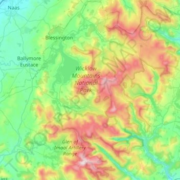
Carte topographique Wicklow Mountains National Park
Carte interactive
Cliquez sur la carte pour afficher l’altitude.
À propos de cette carte
Nom : Carte topographique Wicklow Mountains National Park, altitude, relief.
Altitude moyenne : 322 m
Altitude minimum : 74 m
Altitude maximum : 925 m
Autres cartes topographiques
Cliquez sur une carte pour visualiser sa topographie, son altitude et son relief.
Yardland
Yardland, Arklow No 1 Urban ED, The Municipal District of Arklow, County Wicklow, Leinster, Ireland
Altitude moyenne : 23 m
Aughrim
Aughrim, The Municipal District of Arklow, County Wicklow, Leinster, Y14 HT72, Ireland
Altitude moyenne : 123 m
Vartry Reservoir Lower
Vartry Reservoir Lower, Altidore ED, The Municipal District of Wicklow, County Wicklow, Leinster, Ireland
Altitude moyenne : 229 m
Clone
Clone, Aughrim ED, The Municipal District of Arklow, County Wicklow, Leinster, Ireland
Altitude moyenne : 172 m
Mullaghcleevaun
Mullaghcleevaun, The Municipal District of Wicklow, County Wicklow, Leinster, Ireland
Altitude moyenne : 654 m
Ballintemple
Ballintemple, Arklow Rural ED, The Municipal District of Arklow, County Wicklow, Leinster, Ireland
Altitude moyenne : 115 m
Blessington
Blessington, County Wicklow, Leinster, Ireland
Altitude moyenne : 204 m
Ballyknockan
Ballyknockan, The Municipal District of Baltinglass, County Wicklow, Leinster, Ireland
Altitude moyenne : 309 m
Baltinglass
Baltinglass, Baltinglass ED, The Municipal District of Baltinglass, County Wicklow, Leinster, Ireland
Altitude moyenne : 163 m
Fassaroe
Fassaroe, Ballywaltrim, Kilmacanoge ED, The Municipal District of Bray, County Wicklow, Leinster, Ireland
Altitude moyenne : 67 m
Lough Tay
Lough Tay, Glendalough ED, The Municipal District of Wicklow, County Wicklow, Leinster, Ireland
Altitude moyenne : 395 m
Greystones
Ireland > County Wicklow > Greystones
Greystones, The Municipal District of Greystones, County Wicklow, Leinster, A63 HW80, Ireland
Altitude moyenne : 49 m
Newtown Mountkennedy
Newtown Mountkennedy, Newcastle Upper ED, The Municipal District of Wicklow, County Wicklow, Leinster, A63 FX72, Ireland
Altitude moyenne : 118 m
Ballinaclash
Ballinaclash, Ballinaclash ED, The Municipal District of Arklow, County Wicklow, Leinster, Ireland
Altitude moyenne : 131 m
Greenan More
Greenan More, Ballinderry ED, The Municipal District of Arklow, County Wicklow, Leinster, Ireland
Altitude moyenne : 151 m
Tinahely
Tinahely, Tinahely ED, The Municipal District of Baltinglass, County Wicklow, Leinster, Ireland
Altitude moyenne : 153 m
Tonelagee
Tonelagee, The Municipal District of Wicklow, County Wicklow, Leinster, Ireland
Altitude moyenne : 574 m
Tiknock
Tiknock, Arklow No 2 Urban ED, The Municipal District of Arklow, County Wicklow, Leinster, Ireland
Altitude moyenne : 15 m
The Municipal District of Arklow
The Municipal District of Arklow, County Wicklow, Leinster, Ireland
Altitude moyenne : 155 m
Ballinglen
Ballinglen, Ballinglen ED, The Municipal District of Baltinglass, County Wicklow, Leinster, Ireland
Altitude moyenne : 181 m
Kilcashel
Kilcashel, Avoca ED, The Municipal District of Arklow, County Wicklow, Leinster, Ireland
Altitude moyenne : 138 m
Drummin
Drummin, Ballinglen ED, The Municipal District of Baltinglass, County Wicklow, Leinster, Ireland
Altitude moyenne : 106 m
Avoca
Ireland > County Wicklow > Avoca
Avoca, The Municipal District of Arklow, County Wicklow, Leinster, Ireland
Altitude moyenne : 117 m
Delgany
Ireland > County Wicklow > Delgany
Delgany, The Municipal District of Greystones, County Wicklow, Leinster, A63 YC93, Ireland
Altitude moyenne : 87 m
Newcastle
Ireland > County Wicklow > Newcastle
Newcastle, The Municipal District of Greystones, County Wicklow, Leinster, A63 K062, Ireland
Altitude moyenne : 32 m
Ashford
Ireland > County Wicklow > Ashford
Ashford, The Municipal District of Wicklow, County Wicklow, Leinster, A67 XV22, Ireland
Altitude moyenne : 50 m
Avoca
Avoca, The Municipal District of Arklow, County Wicklow, Leinster, Y14 EW62, Ireland
Altitude moyenne : 117 m
The Municipal District of Wicklow
The Municipal District of Wicklow, County Wicklow, Leinster, Ireland
Altitude moyenne : 263 m
Bray
Ireland > County Wicklow > Bray
Bray, The Municipal District of Bray, County Wicklow, Leinster, A98 V827, Ireland
Altitude moyenne : 58 m
Rathdrum
Ireland > County Wicklow > Rathdrum
Rathdrum, The Municipal District of Arklow, County Wicklow, Leinster, A67 CX62, Ireland
Altitude moyenne : 155 m
Arklow
Arklow, Arklow No 1 Urban ED, The Municipal District of Arklow, County Wicklow, Leinster, Ireland
Altitude moyenne : 14 m
Maghera More
Maghera More, Dunganstown East ED, The Municipal District of Wicklow, County Wicklow, Leinster, Ireland
Altitude moyenne : 23 m
Garrymore Lower
Garrymore Lower, Rathdrum ED, The Municipal District of Arklow, County Wicklow, Leinster, Ireland
Altitude moyenne : 139 m
Dunlavin Lower
Dunlavin Lower, Dunlavin ED, The Municipal District of Baltinglass, County Wicklow, Leinster, Ireland
Altitude moyenne : 153 m
The Municipal District of Bray
The Municipal District of Bray, County Wicklow, Leinster, Ireland
Altitude moyenne : 283 m
The Municipal District of Baltinglass
The Municipal District of Baltinglass, County Wicklow, Leinster, Ireland
Altitude moyenne : 182 m
Ballydonagh
Ballydonagh, Delgany ED, The Municipal District of Greystones, County Wicklow, Leinster, Ireland
Altitude moyenne : 138 m
Boleycarrigeen
Boleycarrigeen, Eadestown ED, The Municipal District of Baltinglass, County Wicklow, Leinster, Ireland
Altitude moyenne : 279 m
Aughrim
Ireland > County Wicklow > Aughrim
Aughrim, The Municipal District of Arklow, County Wicklow, Leinster, Ireland
Altitude moyenne : 175 m
Rathnew
Ireland > County Wicklow > Rathnew
Rathnew, The Municipal District of Wicklow, County Wicklow, Leinster, A67 XV22, Ireland
Altitude moyenne : 35 m
Newtown Mount Kennedy
Ireland > County Wicklow > Newtown Mount Kennedy
Newtown Mount Kennedy, The Municipal District of Wicklow, County Wicklow, Leinster, A63 FX72, Ireland
Altitude moyenne : 109 m