
Carte topographique Yardland
Carte interactive
Cliquez sur la carte pour afficher l’altitude.
À propos de cette carte
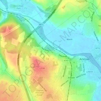
Nom : Carte topographique Yardland, altitude, relief.
Altitude moyenne : 23 m
Altitude minimum : -1 m
Altitude maximum : 56 m
Autres cartes topographiques
Cliquez sur une carte pour visualiser sa topographie, son altitude et son relief.
Aughrim
Aughrim, The Municipal District of Arklow, County Wicklow, Leinster, Y14 HT72, Ireland
Altitude moyenne : 123 m
Vartry Reservoir Lower
Vartry Reservoir Lower, Altidore ED, The Municipal District of Wicklow, County Wicklow, Leinster, Ireland
Altitude moyenne : 229 m
Clone
Clone, Aughrim ED, The Municipal District of Arklow, County Wicklow, Leinster, Ireland
Altitude moyenne : 172 m
Mullaghcleevaun
Mullaghcleevaun, The Municipal District of Wicklow, County Wicklow, Leinster, Ireland
Altitude moyenne : 654 m
Ballintemple
Ballintemple, Arklow Rural ED, The Municipal District of Arklow, County Wicklow, Leinster, Ireland
Altitude moyenne : 115 m
Blessington
Blessington, County Wicklow, Leinster, Ireland
Altitude moyenne : 204 m
Ballyknockan
Ballyknockan, The Municipal District of Baltinglass, County Wicklow, Leinster, Ireland
Altitude moyenne : 309 m
Baltinglass
Baltinglass, Baltinglass ED, The Municipal District of Baltinglass, County Wicklow, Leinster, Ireland
Altitude moyenne : 163 m
Fassaroe
Fassaroe, Ballywaltrim, Kilmacanoge ED, The Municipal District of Bray, County Wicklow, Leinster, Ireland
Altitude moyenne : 67 m
Lough Tay
Lough Tay, Glendalough ED, The Municipal District of Wicklow, County Wicklow, Leinster, Ireland
Altitude moyenne : 395 m
Newtown Mountkennedy
Newtown Mountkennedy, Newcastle Upper ED, The Municipal District of Wicklow, County Wicklow, Leinster, A63 FX72, Ireland
Altitude moyenne : 118 m
Ballinaclash
Ballinaclash, Ballinaclash ED, The Municipal District of Arklow, County Wicklow, Leinster, Ireland
Altitude moyenne : 131 m
Greystones
Ireland > County Wicklow > Greystones
Greystones, The Municipal District of Greystones, County Wicklow, Leinster, A63 HW80, Ireland
Altitude moyenne : 49 m
Greenan More
Greenan More, Ballinderry ED, The Municipal District of Arklow, County Wicklow, Leinster, Ireland
Altitude moyenne : 151 m
Tinahely
Tinahely, Tinahely ED, The Municipal District of Baltinglass, County Wicklow, Leinster, Ireland
Altitude moyenne : 153 m
Tonelagee
Tonelagee, The Municipal District of Wicklow, County Wicklow, Leinster, Ireland
Altitude moyenne : 574 m
Tiknock
Tiknock, Arklow No 2 Urban ED, The Municipal District of Arklow, County Wicklow, Leinster, Ireland
Altitude moyenne : 15 m
The Municipal District of Arklow
The Municipal District of Arklow, County Wicklow, Leinster, Ireland
Altitude moyenne : 155 m
Ballinglen
Ballinglen, Ballinglen ED, The Municipal District of Baltinglass, County Wicklow, Leinster, Ireland
Altitude moyenne : 181 m
Kilcashel
Kilcashel, Avoca ED, The Municipal District of Arklow, County Wicklow, Leinster, Ireland
Altitude moyenne : 138 m
Drummin
Drummin, Ballinglen ED, The Municipal District of Baltinglass, County Wicklow, Leinster, Ireland
Altitude moyenne : 106 m
Avoca
Ireland > County Wicklow > Avoca
Avoca, The Municipal District of Arklow, County Wicklow, Leinster, Ireland
Altitude moyenne : 117 m
Delgany
Ireland > County Wicklow > Delgany
Delgany, The Municipal District of Greystones, County Wicklow, Leinster, A63 YC93, Ireland
Altitude moyenne : 87 m
Newcastle
Ireland > County Wicklow > Newcastle
Newcastle, The Municipal District of Greystones, County Wicklow, Leinster, A63 K062, Ireland
Altitude moyenne : 32 m
Ashford
Ireland > County Wicklow > Ashford
Ashford, The Municipal District of Wicklow, County Wicklow, Leinster, A67 XV22, Ireland
Altitude moyenne : 50 m
Avoca
Avoca, The Municipal District of Arklow, County Wicklow, Leinster, Y14 EW62, Ireland
Altitude moyenne : 117 m
The Municipal District of Wicklow
The Municipal District of Wicklow, County Wicklow, Leinster, Ireland
Altitude moyenne : 263 m
Wicklow Mountains National Park
Wicklow Mountains National Park, County Wicklow, Leinster, Ireland
Altitude moyenne : 322 m
Bray
Ireland > County Wicklow > Bray
Bray, The Municipal District of Bray, County Wicklow, Leinster, A98 V827, Ireland
Altitude moyenne : 58 m
Rathdrum
Ireland > County Wicklow > Rathdrum
Rathdrum, The Municipal District of Arklow, County Wicklow, Leinster, A67 CX62, Ireland
Altitude moyenne : 155 m
Arklow
Arklow, Arklow No 1 Urban ED, The Municipal District of Arklow, County Wicklow, Leinster, Ireland
Altitude moyenne : 14 m
Maghera More
Maghera More, Dunganstown East ED, The Municipal District of Wicklow, County Wicklow, Leinster, Ireland
Altitude moyenne : 23 m
Garrymore Lower
Garrymore Lower, Rathdrum ED, The Municipal District of Arklow, County Wicklow, Leinster, Ireland
Altitude moyenne : 139 m
Dunlavin Lower
Dunlavin Lower, Dunlavin ED, The Municipal District of Baltinglass, County Wicklow, Leinster, Ireland
Altitude moyenne : 153 m
The Municipal District of Bray
The Municipal District of Bray, County Wicklow, Leinster, Ireland
Altitude moyenne : 283 m
The Municipal District of Baltinglass
The Municipal District of Baltinglass, County Wicklow, Leinster, Ireland
Altitude moyenne : 182 m
Ballydonagh
Ballydonagh, Delgany ED, The Municipal District of Greystones, County Wicklow, Leinster, Ireland
Altitude moyenne : 138 m
Boleycarrigeen
Boleycarrigeen, Eadestown ED, The Municipal District of Baltinglass, County Wicklow, Leinster, Ireland
Altitude moyenne : 279 m
Aughrim
Ireland > County Wicklow > Aughrim
Aughrim, The Municipal District of Arklow, County Wicklow, Leinster, Ireland
Altitude moyenne : 175 m
Rathnew
Ireland > County Wicklow > Rathnew
Rathnew, The Municipal District of Wicklow, County Wicklow, Leinster, A67 XV22, Ireland
Altitude moyenne : 35 m
Newtown Mount Kennedy
Ireland > County Wicklow > Newtown Mount Kennedy
Newtown Mount Kennedy, The Municipal District of Wicklow, County Wicklow, Leinster, A63 FX72, Ireland
Altitude moyenne : 109 m