
Carte topographique Storrs
Cliquez sur la carte pour afficher l’altitude.
À propos de cette carte
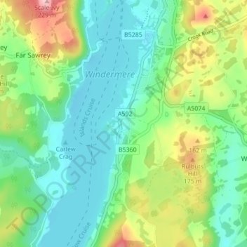
Nom : Carte topographique Storrs, altitude, relief.
Altitude moyenne : 93 m
Altitude minimum : 36 m
Altitude maximum : 226 m
Autres cartes topographiques
Cliquez sur une carte pour visualiser sa topographie, son altitude et son relief.
Windermere
United Kingdom > England > Cumbria > South Lakeland > Bowness-on-Windermere
There is debate as to whether the stretch of water between Newby Bridge and Lakeside at the southern end of the lake should be considered part of Windermere, or a navigable stretch of the River Leven. This affects the stated length of the lake, which is 11.23 miles (18.07 km) long if measured from the bridge…
Altitude moyenne : 132 m