
Carte topographique Sanderau
Carte interactive
Cliquez sur la carte pour afficher l’altitude.
À propos de cette carte
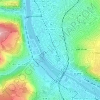
Nom : Carte topographique Sanderau, altitude, relief.
Lieu : Sanderau, Würzburg, Unterfranken, Bayern, 97072, Deutschland (49.76539 9.92705 49.78944 9.95446)
Altitude moyenne : 214 m
Altitude minimum : 170 m
Altitude maximum : 333 m
Autres cartes topographiques
Cliquez sur une carte pour visualiser sa topographie, son altitude et son relief.
Würzburg
Deutschland > Bayern > Würzburg
Würzburg, Unterfranken, Bayern, 97070, Deutschland
Altitude moyenne : 281 m
Würzburg Altstadt
Deutschland > Bayern > Würzburg
Würzburg Altstadt, Würzburg, Unterfranken, Bayern, 97070, Deutschland
Altitude moyenne : 204 m
Heidingsfeld
Deutschland > Bayern > Würzburg
Heidingsfeld, Würzburg, Bayern, Deutschland
Altitude moyenne : 244 m
Grünbrücke Guttenberger Forst
Deutschland > Bayern > Würzburg
Grünbrücke Guttenberger Forst, Steinbachtal, Würzburg, Bayern, 97082, Deutschland
Altitude moyenne : 318 m
Lengfeld
Deutschland > Bayern > Würzburg
Lengfeld, Würzburg, Bayern, 97076, Deutschland
Altitude moyenne : 237 m
Steinbachtal
Deutschland > Bayern > Würzburg
Steinbachtal, Würzburg, Bayern, 97082, Deutschland
Altitude moyenne : 262 m
Rottenbauer
Deutschland > Bayern > Würzburg
Rottenbauer, Würzburg, Bayern, Deutschland
Altitude moyenne : 267 m
Versbach
Deutschland > Bayern > Würzburg
Versbach, Würzburg, Bayern, Deutschland
Altitude moyenne : 267 m
Lindleinsmühle
Deutschland > Bayern > Würzburg
Lindleinsmühle, Würzburg, Unterfranken, Bayern, 97078, Deutschland
Altitude moyenne : 230 m