
Faire un don
Équipez-vous pour votre prochaine aventure :
En tant que Partenaire Amazon, ce site perçoit une commission sur les achats éligibles sans surcoût pour vous.
Carte topographique Heidingsfeld
Cliquez sur la carte pour afficher l’altitude.
Faire un don
Équipez-vous pour votre prochaine aventure :
En tant que Partenaire Amazon, ce site perçoit une commission sur les achats éligibles sans surcoût pour vous.
Heidingsfeld
Heidingsfeld war von 1367 bis 1929 eine eigenständige Stadt. Daher leitet sich die heutige umgangssprachliche Bezeichnung „Städtle“ (für den Heidingsfelder Altort) ab, da Heidingsfeld (1818 mit weniger als 500 dort lebenden Familien noch als „Stadt III. Klasse“ bezeichnet) quasi eine kleine Stadt in der großen Stadt Würzburg darstellt. Seit 1909 gab es Bestrebungen zur Anbindung Heidingsfelds an Würzburg. Nachdem der Würzburger Stadtrat am 28. März und 28. Oktober 1913 eine Eingemeindung mit knapper Mehrheit abgelehnt hatte, wurde Heidingsfeld am 1. Januar 1930 unter den Bürgermeistern Hans Löffler (Würzburg) und Max Schnabel (Heidingsfeld) auf Wunsch der Bürger nach einer Abstimmung nach Würzburg eingemeindet. Damit (vermehrt um 5700 Einwohner und 2466 Hektar Gemarkungsfläche) wurde Würzburg Großstadt. 1850 wurde in Heidingsfeld ein Krankenhaus errichtet. 1855 gründeten die Armen Schulschwestern eine Höhere Töchterschule und weiteten dann ihre Betreuungstätigkeit 1857 und 1867 auf zwei weitere Mädchenschulen sowie 1859 auf das Bezirkswaisenhaus aus. 1864 erhielt Heidingsfeld eine Feuerwehr.
Faire un don
Équipez-vous pour votre prochaine aventure :
En tant que Partenaire Amazon, ce site perçoit une commission sur les achats éligibles sans surcoût pour vous.
À propos de cette carte
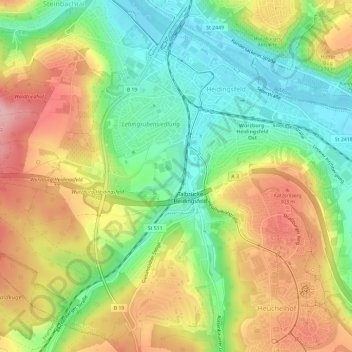
Nom : Carte topographique Heidingsfeld, altitude, relief.
Lieu : Heidingsfeld, Würzburg, Bayern, Deutschland (49.73848 9.92658 49.77142 9.98539)
Altitude moyenne : 244 m
Altitude minimum : 170 m
Altitude maximum : 333 m
Faire un don
Équipez-vous pour votre prochaine aventure :
En tant que Partenaire Amazon, ce site perçoit une commission sur les achats éligibles sans surcoût pour vous.