
Carte topographique Sanbornton
Carte interactive
Cliquez sur la carte pour afficher l’altitude.
À propos de cette carte
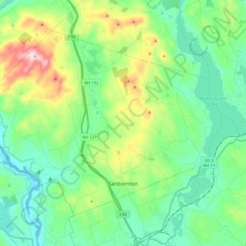
Nom : Carte topographique Sanbornton, altitude, relief.
Altitude moyenne : 228 m
Altitude minimum : 91 m
Altitude maximum : 599 m
According to the United States Census Bureau, the town has a total area of 49.7 square miles (128.6 km2), of which 47.4 sq mi (122.7 km2) are land and 2.3 sq mi (5.9 km2) are water, comprising 4.58% of the town. Bounded on the west by the Pemigewasset River and on the east by Lake Winnisquam, Sanbornton is largely drained by Salmon Brook, a tributary of the Pemigewasset. The highest point in town is the summit of Hersey Mountain, elevation 2,001 feet (610 m) above sea level, along the town's northwestern border.
Autres cartes topographiques
Cliquez sur une carte pour visualiser sa topographie, son altitude et son relief.
Winnisquam
United States > New Hampshire > Belknap County > Tilton
Winnisquam, Tilton, Belknap County, New Hampshire, 03289, United States
Altitude moyenne : 175 m
Glendale
United States > New Hampshire > Belknap County > Gilford
Glendale, Gilford, Belknap County, New Hampshire, 03249, United States
Altitude moyenne : 181 m
Weirs Beach
United States > New Hampshire > Belknap County > Laconia > Interlaken Park
Weirs Beach, Interlaken Park, Laconia, Belknap County, New Hampshire, 03247, United States
Altitude moyenne : 179 m
Lakeport
United States > New Hampshire > Belknap County > Laconia
Lakeport, Laconia, Belknap County, New Hampshire, 03246, United States
Altitude moyenne : 180 m
Squam Lake
United States > New Hampshire > Belknap County > Center Harbor
Squam Lake, Center Harbor, Belknap County, New Hampshire, United States
Altitude moyenne : 220 m
Hopkinson Hill
United States > New Hampshire > Belknap County > Sanbornton
Hopkinson Hill, Sanbornton, Belknap County, New Hampshire, 03269, United States
Altitude moyenne : 292 m
Meredith
United States > New Hampshire > Belknap County
Meredith, Belknap County, New Hampshire, 03253, United States
Altitude moyenne : 215 m
Lake Manning
United States > New Hampshire > Belknap County > Gilmanton
Lake Manning, Gilmanton, Belknap County, New Hampshire, United States
Altitude moyenne : 248 m
Sunset Lake
United States > New Hampshire > Belknap County > Alton
Sunset Lake, Alton, Belknap County, New Hampshire, United States
Altitude moyenne : 268 m
Gilford
United States > New Hampshire > Belknap County
Gilford, Belknap County, New Hampshire, 03249, United States
Altitude moyenne : 231 m
Laconia
United States > New Hampshire > Belknap County
Laconia, Belknap County, New Hampshire, United States
Altitude moyenne : 203 m
Governors Island
United States > New Hampshire > Belknap County > Gilford > Dockham Shore
Governors Island, Dockham Shore, Gilford, Belknap County, New Hampshire, United States
Altitude moyenne : 162 m
Alton
United States > New Hampshire > Belknap County
Alton, Belknap County, New Hampshire, United States
Altitude moyenne : 235 m
Lochmere
United States > New Hampshire > Belknap County > Belmont
Lochmere, Belmont, Belknap County, New Hampshire, 03252, United States
Altitude moyenne : 173 m
Adams Pond;Adams Pond Dam
United States > New Hampshire > Belknap County > Alton
Adams Pond;Adams Pond Dam, Alton, Belknap County, New Hampshire, 03809, United States
Altitude moyenne : 252 m
Gilmanton Ironworks
United States > New Hampshire > Belknap County > Gilmanton
Gilmanton Ironworks, Gilmanton, Belknap County, New Hampshire, 03837, United States
Altitude moyenne : 224 m
Gilmanton
United States > New Hampshire > Belknap County
Gilmanton, Belknap County, New Hampshire, United States
Altitude moyenne : 257 m
Welch Island
United States > New Hampshire > Belknap County > Gilford
Welch Island, Gilford, Belknap County, New Hampshire, United States
Altitude moyenne : 153 m
Gunstock Mountain
United States > New Hampshire > Belknap County > Gilford
Gunstock Mountain, Gilford, Belknap County, New Hampshire, 03249, United States
Altitude moyenne : 456 m
Center Harbor
United States > New Hampshire > Belknap County
Center Harbor, Belknap County, New Hampshire, United States
Altitude moyenne : 214 m
Laconia
United States > New Hampshire > Belknap County > Laconia
Laconia, Belknap County, New Hampshire, 03246, United States
Altitude moyenne : 227 m
Yale Estates
United States > New Hampshire > Belknap County > Gilford > Yale Estates
Yale Estates, Gilford, Belknap County, New Hampshire, United States
Altitude moyenne : 390 m
Winona
United States > New Hampshire > Belknap County > New Hampton > Winona
Winona, New Hampton, Belknap County, New Hampshire, United States
Altitude moyenne : 232 m
Tilton
United States > New Hampshire > Belknap County
Tilton, Belknap County, New Hampshire, United States
Altitude moyenne : 196 m
Center Barnstead
United States > New Hampshire > Belknap County > Barnstead
Center Barnstead, Barnstead, Belknap County, New Hampshire, 03218, United States
Altitude moyenne : 183 m
New Hampton
United States > New Hampshire > Belknap County
New Hampton, Belknap County, New Hampshire, 03256, United States
Altitude moyenne : 264 m
Belmont
United States > New Hampshire > Belknap County
Belmont, Belknap County, New Hampshire, United States
Altitude moyenne : 232 m
Belknap Mountain
United States > New Hampshire > Belknap County > Gilford
Belknap Mountain, Gilford, Belknap County, New Hampshire, 03249, United States
Altitude moyenne : 498 m
Alton Bay
United States > New Hampshire > Belknap County > Alton
Alton Bay, Alton, Belknap County, New Hampshire, 03809, United States
Altitude moyenne : 226 m