
Carte topographique Gunstock Mountain
Carte interactive
Cliquez sur la carte pour afficher l’altitude.
À propos de cette carte
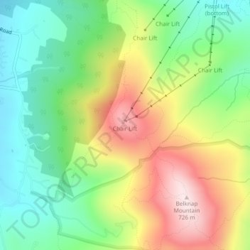
Nom : Carte topographique Gunstock Mountain, altitude, relief.
Altitude moyenne : 456 m
Altitude minimum : 271 m
Altitude maximum : 721 m
Autres cartes topographiques
Cliquez sur une carte pour visualiser sa topographie, son altitude et son relief.
Glendale
United States > New Hampshire > Belknap County > Gilford
Glendale, Gilford, Belknap County, New Hampshire, 03249, United States
Altitude moyenne : 181 m
Welch Island
United States > New Hampshire > Belknap County > Gilford
Welch Island, Gilford, Belknap County, New Hampshire, United States
Altitude moyenne : 153 m
Yale Estates
United States > New Hampshire > Belknap County > Gilford > Yale Estates
Yale Estates, Gilford, Belknap County, New Hampshire, United States
Altitude moyenne : 390 m
Belknap Mountain
United States > New Hampshire > Belknap County > Gilford
Belknap Mountain, Gilford, Belknap County, New Hampshire, 03249, United States
Altitude moyenne : 498 m