Géolocaliser

Carte topographique Iwade

Cliquez sur la carte pour afficher l’altitude.

À propos de cette carte

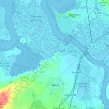
Nom : Carte topographique Iwade, altitude, relief.

Lieu : Iwade, Borough of Swale, Kent, England, United Kingdom (51.36561 0.69233 51.41525 0.76622)

Altitude moyenne : 6 m

Altitude minimum : -5 m

Altitude maximum : 63 m

👉 Easily get elevation data in JSON, GeoTIFF and KML formats using Elevation API
Merci de soutenir ce site ❤️
Faire un don

Équipez-vous pour votre prochaine aventure :

En tant que Partenaire Amazon, ce site perçoit une commission sur les achats éligibles sans surcoût pour vous.

Autres cartes topographiques

Cliquez sur une carte pour visualiser sa topographie, son altitude et son relief.

Sittingbourne

United Kingdom > England > Kent > Borough of Swale

Altitude moyenne : 37 m

The Swale

United Kingdom > England > Kent > Borough of Swale

Altitude moyenne : 12 m

Newhouse

United Kingdom > England > Kent > Borough of Swale

Altitude moyenne : 9 m

Gore

United Kingdom > England > Kent > Borough of Swale > Upchurch

Altitude moyenne : 19 m

Minster

United Kingdom > England > Kent > Borough of Swale

Altitude moyenne : 9 m

Bay View

United Kingdom > England > Kent > Borough of Swale > Warden

Altitude moyenne : 12 m

Keycol Hill

United Kingdom > England > Kent > Borough of Swale

Altitude moyenne : 40 m

Norton Ash

United Kingdom > England > Kent > Borough of Swale > Norton

Altitude moyenne : 30 m

Lower Hartlip

United Kingdom > England > Kent > Borough of Swale > Hartlip

Altitude moyenne : 55 m

Howt Green

United Kingdom > England > Kent > Borough of Swale > Bobbing

Altitude moyenne : 19 m

Key Street

United Kingdom > England > Kent > Borough of Swale > Borden

Altitude moyenne : 40 m

Berryfield

United Kingdom > England > Kent > Borough of Swale > Eastchurch

Altitude moyenne : 22 m

Berryfield

United Kingdom > England > Kent > Borough of Swale > Eastchurch

Altitude moyenne : 22 m

Wallend

United Kingdom > England > Kent > Borough of Swale > Minster

Altitude moyenne : 7 m

Grove End

United Kingdom > England > Kent > Borough of Swale > Tunstall

Altitude moyenne : 65 m

Trouts

United Kingdom > England > Kent > Borough of Swale > Eastchurch

Altitude moyenne : 24 m

Sittingbourne

United Kingdom > England > Kent > Borough of Swale

Altitude moyenne : 37 m

Uplees

United Kingdom > England > Kent > Borough of Swale

Altitude moyenne : 5 m

Hook's Hole

United Kingdom > England > Kent > Borough of Swale > Borden

Altitude moyenne : 45 m

Oare Creek

United Kingdom > England > Kent > Borough of Swale > Faversham > Oare

Altitude moyenne : 6 m

Norton

United Kingdom > England > Kent > Borough of Swale

Altitude moyenne : 35 m

Seed

United Kingdom > England > Kent > Borough of Swale > Doddington

Altitude moyenne : 101 m

Graveney

United Kingdom > England > Kent > Borough of Swale

Altitude moyenne : 8 m

Halfway

United Kingdom > England > Kent > Borough of Swale

Altitude moyenne : 6 m

Great Norwood

United Kingdom > England > Kent > Borough of Swale > Bobbing

Altitude moyenne : 27 m

Lewson Street

United Kingdom > England > Kent > Borough of Swale > Norton

Altitude moyenne : 36 m

Dargate

United Kingdom > England > Kent > Borough of Swale

Altitude moyenne : 40 m

Oversland

United Kingdom > England > Kent > Borough of Swale

Altitude moyenne : 73 m

Ham Green

United Kingdom > England > Kent > Borough of Swale > Upchurch

Altitude moyenne : 4 m

Équipez-vous pour votre prochaine aventure :

🧤Sous-gants en soie - Apport de chaleur naturelle sans épaisseur supplémentaire
🍯Barres énergétiques - Coup de boost rapide lors des ascensions difficiles
Piquets de tente légers - Solidité et légèreté pour remplacer vos piquets d'origine
👖Pantalon de marche modulable - Transformable en short pour s'adapter aux variations météo
🥤Gobelet pliable - Gain de place maximal pour boire aux fontaines

En tant que Partenaire Amazon, ce site perçoit une commission sur les achats éligibles sans surcoût pour vous.