Géolocaliser

Carte topographique Keycol Hill

Cliquez sur la carte pour afficher l’altitude.

À propos de cette carte

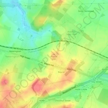
Nom : Carte topographique Keycol Hill, altitude, relief.

Lieu : Keycol Hill, Borough of Swale, Kent, England, ME9 7JF, United Kingdom (51.35209 0.68230 51.35219 0.68240)

Altitude moyenne : 40 m

Altitude minimum : 7 m

Altitude maximum : 76 m

Autres cartes topographiques

Cliquez sur une carte pour visualiser sa topographie, son altitude et son relief.

The Swale

United Kingdom > England > Kent > Borough of Swale

Altitude moyenne : 12 m

Milstead

United Kingdom > England > Kent > Borough of Swale > Milstead

Altitude moyenne : 106 m

Borden

United Kingdom > England > Kent > Borough of Swale > Borden

Altitude moyenne : 64 m

Lower Halstow

United Kingdom > England > Kent > Borough of Swale

Altitude moyenne : 12 m

Newington

United Kingdom > England > Kent > Borough of Swale

Altitude moyenne : 45 m

Bobbing

United Kingdom > England > Kent > Borough of Swale

Altitude moyenne : 32 m

Newnham

United Kingdom > England > Kent > Borough of Swale > Newnham

Altitude moyenne : 89 m

Newnham

United Kingdom > England > Kent > Borough of Swale > Newnham

Altitude moyenne : 89 m

Faversham

United Kingdom > England > Kent > Borough of Swale

Altitude moyenne : 17 m

Hernhill

United Kingdom > England > Kent > Borough of Swale > Dargate

Altitude moyenne : 29 m

Sheldwich

United Kingdom > England > Kent > Borough of Swale

Altitude moyenne : 70 m

Selling

United Kingdom > England > Kent > Borough of Swale

Altitude moyenne : 64 m

Eastchurch

United Kingdom > England > Kent > Borough of Swale

Altitude moyenne : 16 m

Stalisfield

United Kingdom > England > Kent > Borough of Swale

Altitude moyenne : 137 m

Luddenham

United Kingdom > England > Kent > Borough of Swale > Oare

Altitude moyenne : 7 m

Luddenham

United Kingdom > England > Kent > Borough of Swale

Altitude moyenne : 7 m

Oare Creek

United Kingdom > England > Kent > Borough of Swale > Faversham > Oare

Altitude moyenne : 6 m

Faversham

United Kingdom > England > Kent > Borough of Swale > Ospringe

Altitude moyenne : 17 m

Iwade

United Kingdom > England > Kent > Borough of Swale

Altitude moyenne : 6 m

Upchurch

United Kingdom > England > Kent > Borough of Swale

Altitude moyenne : 10 m

Bapchild

United Kingdom > England > Kent > Borough of Swale > Bapchild

Altitude moyenne : 21 m

Sheerness

United Kingdom > England > Kent > Borough of Swale

Altitude moyenne : 3 m

Tonge

United Kingdom > England > Kent > Borough of Swale > Bapchild

Altitude moyenne : 23 m

Hartlip

United Kingdom > England > Kent > Borough of Swale > Hartlip

Altitude moyenne : 70 m

Oare

United Kingdom > England > Kent > Borough of Swale > Oare

Altitude moyenne : 4 m

Queenborough

United Kingdom > England > Kent > Borough of Swale

Altitude moyenne : 2 m

Lewson Street

United Kingdom > England > Kent > Borough of Swale > Norton

Altitude moyenne : 36 m

Bredgar

United Kingdom > England > Kent > Borough of Swale

Altitude moyenne : 100 m

Teynham

United Kingdom > England > Kent > Borough of Swale

Altitude moyenne : 6 m

Doddington

United Kingdom > England > Kent > Borough of Swale > Doddington

Altitude moyenne : 103 m

Sheerness

United Kingdom > England > Kent > Borough of Swale

Altitude moyenne : 3 m

Équipez-vous pour votre prochaine aventure :

🧥Veste coupe-vent - Protection légère contre les courants d'air sur les crêtes
🧥Doudounes compressibles - Isolation légère pour montagne
🧭Boussole de précision - Idéale pour l'orientation avec cartes topographiques en milieu alpin
🗺️Cartes de randonnée - Le support papier indispensable en complément du numérique
🦶Semelles en gel - Amorti supplémentaire pour les articulations sensibles

En tant que Partenaire Amazon, ce site perçoit une commission sur les achats éligibles sans surcoût pour vous.