
Faire un don
Équipez-vous pour votre prochaine aventure :
En tant que Partenaire Amazon, ce site perçoit une commission sur les achats éligibles sans surcoût pour vous.
Carte topographique Nipigon Township
Cliquez sur la carte pour afficher l’altitude.
Faire un don
Équipez-vous pour votre prochaine aventure :
En tant que Partenaire Amazon, ce site perçoit une commission sur les achats éligibles sans surcoût pour vous.
À propos de cette carte
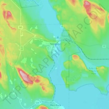
Nom : Carte topographique Nipigon Township, altitude, relief.
Altitude moyenne : 242 m
Altitude minimum : 174 m
Altitude maximum : 461 m
Faire un don
Équipez-vous pour votre prochaine aventure :
En tant que Partenaire Amazon, ce site perçoit une commission sur les achats éligibles sans surcoût pour vous.
Autres cartes topographiques
Cliquez sur une carte pour visualiser sa topographie, son altitude et son relief.
Upsala
Canada > Ontario > Thunder Bay District > Unorganized Thunder Bay District
Altitude moyenne : 487 m
Manitouwadge
Canada > Ontario > Thunder Bay District > Manitouwadge Township > Manitouwadge
Altitude moyenne : 361 m
Whitefish Lake
Canada > Ontario > Thunder Bay District > Unorganized Thunder Bay District
Altitude moyenne : 472 m
Sunbow Lake
Canada > Ontario > Thunder Bay District > Unorganized Thunder Bay District
Altitude moyenne : 491 m
Faire un don
Équipez-vous pour votre prochaine aventure :
En tant que Partenaire Amazon, ce site perçoit une commission sur les achats éligibles sans surcoût pour vous.
Sulphur Lake
Canada > Ontario > Thunder Bay District > Unorganized Thunder Bay District
Altitude moyenne : 467 m
Tower Mountain
Canada > Ontario > Thunder Bay District > Unorganized Thunder Bay District
Altitude moyenne : 575 m
Trowbridge Island
Canada > Ontario > Thunder Bay District > Unorganized Thunder Bay District
Altitude moyenne : 179 m
Faire un don
Équipez-vous pour votre prochaine aventure :
En tant que Partenaire Amazon, ce site perçoit une commission sur les achats éligibles sans surcoût pour vous.
Joyce Lake
Canada > Ontario > Thunder Bay District > Unorganized Thunder Bay District
Altitude moyenne : 391 m
Shebandowan
Canada > Ontario > Thunder Bay District > Unorganized Thunder Bay District
Altitude moyenne : 461 m
Faire un don
Équipez-vous pour votre prochaine aventure :
En tant que Partenaire Amazon, ce site perçoit une commission sur les achats éligibles sans surcoût pour vous.
Nolalu
Canada > Ontario > Thunder Bay District > Unorganized Thunder Bay District
Altitude moyenne : 370 m
Tomlinson Lake
Canada > Ontario > Thunder Bay District > Unorganized Thunder Bay District
Altitude moyenne : 489 m
Faire un don
Équipez-vous pour votre prochaine aventure :
En tant que Partenaire Amazon, ce site perçoit une commission sur les achats éligibles sans surcoût pour vous.
Faire un don
Équipez-vous pour votre prochaine aventure :
En tant que Partenaire Amazon, ce site perçoit une commission sur les achats éligibles sans surcoût pour vous.
Sunshine
Canada > Ontario > Thunder Bay District > Unorganized Thunder Bay District
Altitude moyenne : 401 m
Ara Lake
Canada > Ontario > Thunder Bay District > Unorganized Thunder Bay District
Altitude moyenne : 308 m
Faire un don
Équipez-vous pour votre prochaine aventure :
En tant que Partenaire Amazon, ce site perçoit une commission sur les achats éligibles sans surcoût pour vous.
Papineau Lake;Wapoose Creek
Canada > Ontario > Thunder Bay District > Greenstone
Altitude moyenne : 347 m
Paint Lake
Canada > Ontario > Thunder Bay District > Unorganized Thunder Bay District
Altitude moyenne : 450 m
O'Brien Lake
Canada > Ontario > Thunder Bay District > Unorganized Thunder Bay District
Altitude moyenne : 205 m
Timmus Lake
Canada > Ontario > Thunder Bay District > Unorganized Thunder Bay District
Altitude moyenne : 461 m
Faire un don
Équipez-vous pour votre prochaine aventure :
En tant que Partenaire Amazon, ce site perçoit une commission sur les achats éligibles sans surcoût pour vous.
Shabaqua Corners
Canada > Ontario > Thunder Bay District > Unorganized Thunder Bay District
Altitude moyenne : 416 m
Rossport
Canada > Ontario > Thunder Bay District > Unorganized Thunder Bay District
Altitude moyenne : 227 m
Springpole Island
Canada > Ontario > Thunder Bay District > Unorganized Thunder Bay District
Altitude moyenne : 289 m
Faire un don
Équipez-vous pour votre prochaine aventure :
En tant que Partenaire Amazon, ce site perçoit une commission sur les achats éligibles sans surcoût pour vous.
Cash Creek
Canada > Ontario > Thunder Bay District > Unorganized Thunder Bay District
Altitude moyenne : 221 m
Cola Creek
Canada > Ontario > Thunder Bay District > Unorganized Thunder Bay District
Altitude moyenne : 479 m
Squash Lake
Canada > Ontario > Thunder Bay District > Unorganized Thunder Bay District
Altitude moyenne : 348 m
Faire un don
Équipez-vous pour votre prochaine aventure :
En tant que Partenaire Amazon, ce site perçoit une commission sur les achats éligibles sans surcoût pour vous.
Rossport
Canada > Ontario > Thunder Bay District > Unorganized Thunder Bay District
Altitude moyenne : 227 m
Topaz Lake
Canada > Ontario > Thunder Bay District > Unorganized Thunder Bay District
Altitude moyenne : 482 m
Faire un don
Équipez-vous pour votre prochaine aventure :
En tant que Partenaire Amazon, ce site perçoit une commission sur les achats éligibles sans surcoût pour vous.