
Faire un don
Équipez-vous pour votre prochaine aventure :
En tant que Partenaire Amazon, ce site perçoit une commission sur les achats éligibles sans surcoût pour vous.
Carte topographique Longlac
Cliquez sur la carte pour afficher l’altitude.
Faire un don
Équipez-vous pour votre prochaine aventure :
En tant que Partenaire Amazon, ce site perçoit une commission sur les achats éligibles sans surcoût pour vous.
À propos de cette carte
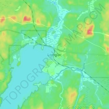
Nom : Carte topographique Longlac, altitude, relief.
Altitude moyenne : 323 m
Altitude minimum : 309 m
Altitude maximum : 364 m
Faire un don
Équipez-vous pour votre prochaine aventure :
En tant que Partenaire Amazon, ce site perçoit une commission sur les achats éligibles sans surcoût pour vous.
Autres cartes topographiques
Cliquez sur une carte pour visualiser sa topographie, son altitude et son relief.
Wapikaimaski Lake
Canada > Ontario > Thunder Bay District > Unorganized Thunder Bay District
Altitude moyenne : 437 m
Faire un don
Équipez-vous pour votre prochaine aventure :
En tant que Partenaire Amazon, ce site perçoit une commission sur les achats éligibles sans surcoût pour vous.
Whitefish Lake
Canada > Ontario > Thunder Bay District > Unorganized Thunder Bay District
Altitude moyenne : 472 m
Lac des Mille Lacs
Canada > Ontario > Thunder Bay District > Unorganized Thunder Bay District
Altitude moyenne : 469 m
Sunbow Lake
Canada > Ontario > Thunder Bay District > Unorganized Thunder Bay District
Altitude moyenne : 491 m
Faire un don
Équipez-vous pour votre prochaine aventure :
En tant que Partenaire Amazon, ce site perçoit une commission sur les achats éligibles sans surcoût pour vous.
Ouimet Canyon Provincial Park
Canada > Ontario > Thunder Bay District > Dorion Township
Altitude moyenne : 364 m
Sulphur Lake
Canada > Ontario > Thunder Bay District > Unorganized Thunder Bay District
Altitude moyenne : 467 m
Faire un don
Équipez-vous pour votre prochaine aventure :
En tant que Partenaire Amazon, ce site perçoit une commission sur les achats éligibles sans surcoût pour vous.
Trowbridge Island
Canada > Ontario > Thunder Bay District > Unorganized Thunder Bay District
Altitude moyenne : 179 m
Lower Ross Lake
Canada > Ontario > Thunder Bay District > Unorganized Thunder Bay District
Altitude moyenne : 393 m
Joyce Lake
Canada > Ontario > Thunder Bay District > Unorganized Thunder Bay District
Altitude moyenne : 391 m
Quint Island Lake;Shacabac Creek
Canada > Ontario > Thunder Bay District > Unorganized Thunder Bay District
Altitude moyenne : 283 m
Faire un don
Équipez-vous pour votre prochaine aventure :
En tant que Partenaire Amazon, ce site perçoit une commission sur les achats éligibles sans surcoût pour vous.
Whitefish Lake
Canada > Ontario > Thunder Bay District > Unorganized Thunder Bay District > Suomi
Altitude moyenne : 456 m
Faire un don
Équipez-vous pour votre prochaine aventure :
En tant que Partenaire Amazon, ce site perçoit une commission sur les achats éligibles sans surcoût pour vous.
Tomlinson Lake
Canada > Ontario > Thunder Bay District > Unorganized Thunder Bay District
Altitude moyenne : 489 m
Arrow Lake
Canada > Ontario > Thunder Bay District > Unorganized Thunder Bay District
Altitude moyenne : 521 m
Pass Lake
Canada > Ontario > Thunder Bay District > Unorganized Thunder Bay District
Altitude moyenne : 259 m
Faire un don
Équipez-vous pour votre prochaine aventure :
En tant que Partenaire Amazon, ce site perçoit une commission sur les achats éligibles sans surcoût pour vous.
Miniss Lake
Canada > Ontario > Thunder Bay District > Unorganized Thunder Bay District
Altitude moyenne : 394 m
Sleeping Giant Provincial Park
Canada > Ontario > Thunder Bay District > Unorganized Thunder Bay District
Altitude moyenne : 204 m
Faire un don
Équipez-vous pour votre prochaine aventure :
En tant que Partenaire Amazon, ce site perçoit une commission sur les achats éligibles sans surcoût pour vous.
Perute Lake
Canada > Ontario > Thunder Bay District > Unorganized Thunder Bay District
Altitude moyenne : 410 m
Harvey Lake
Canada > Ontario > Thunder Bay District > Unorganized Thunder Bay District
Altitude moyenne : 297 m
Horne Creek;Horne Lake
Canada > Ontario > Thunder Bay District > Unorganized Thunder Bay District
Altitude moyenne : 443 m
Faire un don
Équipez-vous pour votre prochaine aventure :
En tant que Partenaire Amazon, ce site perçoit une commission sur les achats éligibles sans surcoût pour vous.
Ruffle Lake
Canada > Ontario > Thunder Bay District > Unorganized Thunder Bay District
Altitude moyenne : 326 m
Ara Lake
Canada > Ontario > Thunder Bay District > Unorganized Thunder Bay District
Altitude moyenne : 308 m
Papineau Lake;Wapoose Creek
Canada > Ontario > Thunder Bay District > Greenstone
Altitude moyenne : 347 m
Faire un don
Équipez-vous pour votre prochaine aventure :
En tant que Partenaire Amazon, ce site perçoit une commission sur les achats éligibles sans surcoût pour vous.
Paint Lake
Canada > Ontario > Thunder Bay District > Unorganized Thunder Bay District
Altitude moyenne : 450 m
O'Brien Lake
Canada > Ontario > Thunder Bay District > Unorganized Thunder Bay District
Altitude moyenne : 205 m
Kapikotongwa River
Canada > Ontario > Thunder Bay District > Unorganized Thunder Bay District
Altitude moyenne : 268 m
Timmus Lake
Canada > Ontario > Thunder Bay District > Unorganized Thunder Bay District
Altitude moyenne : 461 m
Faire un don
Équipez-vous pour votre prochaine aventure :
En tant que Partenaire Amazon, ce site perçoit une commission sur les achats éligibles sans surcoût pour vous.
DeCourcey Lake
Canada > Ontario > Thunder Bay District > Unorganized Thunder Bay District
Altitude moyenne : 457 m
Cash Creek
Canada > Ontario > Thunder Bay District > Unorganized Thunder Bay District
Altitude moyenne : 221 m
Burness Lake
Canada > Ontario > Thunder Bay District > Unorganized Thunder Bay District
Altitude moyenne : 301 m
Faire un don
Équipez-vous pour votre prochaine aventure :
En tant que Partenaire Amazon, ce site perçoit une commission sur les achats éligibles sans surcoût pour vous.
North Lake
Canada > Ontario > Thunder Bay District > Unorganized Thunder Bay District
Altitude moyenne : 523 m
Cola Creek
Canada > Ontario > Thunder Bay District > Unorganized Thunder Bay District
Altitude moyenne : 479 m
Faire un don
Équipez-vous pour votre prochaine aventure :
En tant que Partenaire Amazon, ce site perçoit une commission sur les achats éligibles sans surcoût pour vous.
Whitesand Lake
Canada > Ontario > Thunder Bay District > Unorganized Thunder Bay District
Altitude moyenne : 318 m
Squash Lake
Canada > Ontario > Thunder Bay District > Unorganized Thunder Bay District
Altitude moyenne : 348 m
Faire un don
Équipez-vous pour votre prochaine aventure :
En tant que Partenaire Amazon, ce site perçoit une commission sur les achats éligibles sans surcoût pour vous.
Georgia Lake
Canada > Ontario > Thunder Bay District > Unorganized Thunder Bay District
Altitude moyenne : 459 m
Faire un don
Équipez-vous pour votre prochaine aventure :
En tant que Partenaire Amazon, ce site perçoit une commission sur les achats éligibles sans surcoût pour vous.
Sleeping Giant Provincial Park
Canada > Ontario > Thunder Bay District > Unorganized Thunder Bay District
Altitude moyenne : 204 m
Topaz Lake
Canada > Ontario > Thunder Bay District > Unorganized Thunder Bay District
Altitude moyenne : 482 m
District Lake
Canada > Ontario > Thunder Bay District > Unorganized Thunder Bay District
Altitude moyenne : 481 m
Faire un don
Équipez-vous pour votre prochaine aventure :
En tant que Partenaire Amazon, ce site perçoit une commission sur les achats éligibles sans surcoût pour vous.