Géolocaliser

Carte topographique Lerwick

Cliquez sur la carte pour afficher l’altitude.

Lerwick

Lerwick has transitioned from a subpolar oceanic climate (Cfc) to a maritime climate (Cfb) with cool to cold temperatures all year long. The lack of trees reflects the latter type. This is particularly pronounced by virtue of Lerwick being on the coast of an island, so even extreme temperature records are subdued; the record high stands at just 23.4 °C (74.1 °F) (July 1991) and the record low just −8.9 °C (16.0 °F) (January 1952 and January 1959). Lerwick is also a very cloudy town, averaging only 1,110 sunshine hours annually. February is the coldest month, with high temperatures averaging around 5.5 °C (41.9 °F). In August, the warmest month, average high temperatures are near 14.5 °C (58.1 °F). This produces an extremely narrow difference for an area north of the 60 parallel. In terms of average monthly precipitation, October to January are the year's wettest months, with over 140 mm (5.5 in) of precipitation each month; May and June are the driest months, with average monthly precipitation less than 60 mm (2.4 in) each. Snowfall can occur, primarily from December to March, but snow accumulation is rarely heavy and usually short-lived. The exposed North Atlantic location and proximity to autumn and winter storm tracks means high winds are a regular occurrence, alongside high levels of cloudiness and precipitation. Temperatures are likely to be slightly milder in the town centre at sea level, as the weather station is at an elevation of 82 metres (269 ft).

Wikipedia (CC-BY-SA 3.0)

À propos de cette carte

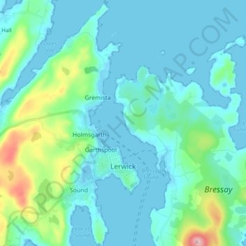
Nom : Carte topographique Lerwick, altitude, relief.

Lieu : Lerwick, Shetland, Scotland, United Kingdom (60.12851 -1.21367 60.20441 -1.13170)

Altitude moyenne : 34 m

Altitude minimum : -9 m

Altitude maximum : 225 m

👉 Easily get elevation data in JSON, GeoTIFF and KML formats using Elevation API
Merci de soutenir ce site ❤️
Faire un don

Équipez-vous pour votre prochaine aventure :

En tant que Partenaire Amazon, ce site perçoit une commission sur les achats éligibles sans surcoût pour vous.

Autres cartes topographiques

Cliquez sur une carte pour visualiser sa topographie, son altitude et son relief.

Scot Knowe

United Kingdom > Scotland > Shetland

Altitude moyenne : 40 m

Fitful Head

United Kingdom > Scotland > Shetland

Altitude moyenne : 68 m

Ronas Hill

United Kingdom > Scotland > Shetland

Ronas Hill (or Rönies Hill) is a hill in Shetland, Scotland. It is classed as a Marilyn, and is the highest point in the Shetland Islands at an elevation of 450 m (1,480 ft). A Neolithic chambered cairn is located near the summit.

Altitude moyenne : 298 m

Da Sneug

United Kingdom > Scotland > Shetland

Altitude moyenne : 125 m

Whalsay

United Kingdom > Scotland > Shetland > Symbister

Altitude moyenne : 12 m

Mousa

United Kingdom > Scotland > Shetland

Altitude moyenne : 3 m

Twatt

United Kingdom > Scotland > Shetland

Altitude moyenne : 35 m

Papa Stour

United Kingdom > Scotland > Shetland

Altitude moyenne : 9 m

Aywick

United Kingdom > Scotland > Shetland

Altitude moyenne : 36 m

Ulsta

United Kingdom > Scotland > Shetland

Altitude moyenne : 23 m

Mid Yell

United Kingdom > Scotland > Shetland

Altitude moyenne : 48 m

Burwick

United Kingdom > Scotland > Shetland > Scalloway

Altitude moyenne : 28 m

Valsgarth

United Kingdom > Scotland > Shetland > Saxa Vord

Altitude moyenne : 45 m

Lamba

United Kingdom > Scotland > Shetland

Altitude moyenne : 1 m

North Gluss

United Kingdom > Scotland > Shetland

Altitude moyenne : 62 m

Papa Stour

United Kingdom > Scotland > Shetland

Altitude moyenne : 9 m

Scalloway

United Kingdom > Scotland > Shetland

Altitude moyenne : 43 m

Saxa Vord

United Kingdom > Scotland > Shetland

Altitude moyenne : 50 m

Hamnafield

United Kingdom > Scotland > Shetland

Altitude moyenne : 117 m

Norwick

United Kingdom > Scotland > Shetland > Saxa Vord

Altitude moyenne : 53 m

Camb

United Kingdom > Scotland > Shetland

Altitude moyenne : 47 m

Bigga

United Kingdom > Scotland > Shetland > Ulsta

Altitude moyenne : 3 m

Kirkabister

United Kingdom > Scotland > Shetland

Altitude moyenne : 38 m

Holm of Melby

United Kingdom > Scotland > Shetland

Altitude moyenne : 4 m

Bigton

United Kingdom > Scotland > Shetland

Altitude moyenne : 66 m

Cunningsburgh

United Kingdom > Scotland > Shetland > Aithsetter

Altitude moyenne : 61 m

Sandwick

United Kingdom > Scotland > Shetland

Altitude moyenne : 18 m

Sumburgh

United Kingdom > Scotland > Shetland > Scatness

Altitude moyenne : 4 m

Brae

United Kingdom > Scotland > Shetland

Altitude moyenne : 38 m

Hamnavoe

United Kingdom > Scotland > Shetland

Altitude moyenne : 6 m

Dale Hill

United Kingdom > Scotland > Shetland

Altitude moyenne : 109 m

Équipez-vous pour votre prochaine aventure :

🍽️Popotes de camping - Ustensiles légers pour repas en bivouac
🧥Veste polaire respirante - Couche intermédiaire idéale pour réguler la température corporelle
🩹Pansements spécial ampoules - Continuez votre marche malgré les frottements
🕶️Cordon pour lunettes - Ne perdez plus vos lunettes lors de vos mouvements brusques
🦵Guêtres de marche - Empêchent la neige, la boue et les cailloux d'entrer dans vos chaussures

En tant que Partenaire Amazon, ce site perçoit une commission sur les achats éligibles sans surcoût pour vous.