
Carte topographique Hamnavoe
Cliquez sur la carte pour afficher l’altitude.
À propos de cette carte
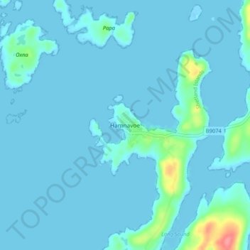
Nom : Carte topographique Hamnavoe, altitude, relief.
Lieu : Hamnavoe, Shetland, Scotland, ZE2 9JY, United Kingdom (60.08629 -1.35743 60.12629 -1.31743)
Altitude moyenne : 6 m
Altitude minimum : -13 m
Altitude maximum : 75 m
Autres cartes topographiques
Cliquez sur une carte pour visualiser sa topographie, son altitude et son relief.
Yell
United Kingdom > Scotland > Shetland
Yell is 19 miles (31 kilometres) in length, with a maximum breadth of 7.5 miles (12.1 kilometres), and is swept all around by very impetuous tides. The island extends northward to within 9.5 miles (15.3 kilometres) of the northwestern extremity of Unst. It is divided by only the narrow Bluemull Sound from the…
Altitude moyenne : 27 m
Lerwick
United Kingdom > Scotland > Shetland
Lerwick has transitioned from a subpolar oceanic climate (Cfc) to a maritime climate (Cfb) with cool to cold temperatures all year long. The lack of trees reflects the latter type. This is particularly pronounced by virtue of Lerwick being on the coast of an island, so even extreme temperature records are…
Altitude moyenne : 34 m
Out Skerries
United Kingdom > Scotland > Shetland
Being so close to Norway, the islands were of strategic importance in World War II and were a regular landfall for Norwegian boats carrying escapees from the Nazi occupation. The local coastguard was responsible for the refugees, and at one point during the war were issued with a tommy gun, although initially…
Altitude moyenne : 1 m
Housay
United Kingdom > Scotland > Shetland
Being so close to Norway, the islands were of strategic importance in World War II and were a regular landfall for Norwegian boats carrying escapees from the Nazi occupation. The local coastguard was responsible for the refugees, and at one point during the war were issued with a tommy gun, although initially…
Altitude moyenne : 3 m