
Carte topographique Helmand
Carte interactive
Cliquez sur la carte pour afficher l’altitude.
À propos de cette carte
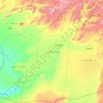
Nom : Carte topographique Helmand, altitude, relief.
Lieu : Helmand, Afghanistan (29.37720 62.55310 33.36983 65.37155)
Altitude moyenne : 1’089 m
Altitude minimum : 452 m
Altitude maximum : 3’981 m
Autres cartes topographiques
Cliquez sur une carte pour visualiser sa topographie, son altitude et son relief.
Kaboul
Afghanistan > Province de Kaboul > District de Kaboul
Kaboul, District de Kaboul, Province de Kaboul, 1001, Afghanistan
Altitude moyenne : 1’945 m
ولسوالی استالف
ولسوالی استالف, ولایت كابل, Afghanistan
Altitude moyenne : 2’559 m
بازار يکاولنگ
Afghanistan > Bâmiyân > بازار يکاولنگ
بازار يکاولنگ, یکاولنگ, Bâmiyân, Afghanistan
Altitude moyenne : 2’874 m
ولسوالی مرکز بهسود
ولسوالی مرکز بهسود, Wardak, Afghanistan
Altitude moyenne : 3’245 m