
Carte topographique Ghazni
Carte interactive
Cliquez sur la carte pour afficher l’altitude.
À propos de cette carte
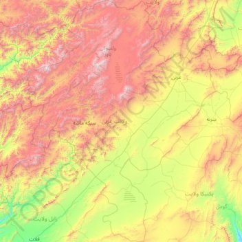
Nom : Carte topographique Ghazni, altitude, relief.
Lieu : Ghazni, Afghanistan (32.07582 66.82336 34.21913 68.82773)
Altitude moyenne : 2’528 m
Altitude minimum : 1’413 m
Altitude maximum : 4’717 m
Autres cartes topographiques
Cliquez sur une carte pour visualiser sa topographie, son altitude et son relief.
Kaboul
Afghanistan > Province de Kaboul > District de Kaboul
Kaboul, District de Kaboul, Province de Kaboul, 1001, Afghanistan
Altitude moyenne : 1’945 m
ولسوالی استالف
ولسوالی استالف, ولایت كابل, Afghanistan
Altitude moyenne : 2’559 m
بازار يکاولنگ
Afghanistan > Bâmiyân > بازار يکاولنگ
بازار يکاولنگ, یکاولنگ, Bâmiyân, Afghanistan
Altitude moyenne : 2’874 m
ولسوالی مرکز بهسود
ولسوالی مرکز بهسود, Wardak, Afghanistan
Altitude moyenne : 3’245 m