
Carte topographique Cambridge
Carte interactive
Cliquez sur la carte pour afficher l’altitude.
À propos de cette carte
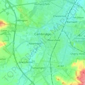
Nom : Carte topographique Cambridge, altitude, relief.
Altitude moyenne : 18 m
Altitude minimum : 2 m
Altitude maximum : 80 m
The city, like most of the UK, has a maritime climate highly influenced by the Gulf Stream. Located in the driest region of Britain, Cambridge's rainfall averages around 570 mm (22.44 in) per year, around half the national average, The driest recent year was in 2011 with 380.4 mm (14.98 in) of rain at the Botanic Garden and 347.2 mm (13.67 in) at the NIAB site. This is just below the semi-arid precipitation threshold for the area, which is 350mm of annual precipitation. Conversely, 2012 was the wettest year on record, with 812.7 mm (32.00 in) reported. Snowfall accumulations are usually small, in part because of Cambridge's low elevation, and low precipitation tendency during transitional snow events.
Autres cartes topographiques
Cliquez sur une carte pour visualiser sa topographie, son altitude et son relief.
South Cambridgeshire
United Kingdom > England > Cambridgeshire
South Cambridgeshire, Cambridgeshire, Cambridgeshire and Peterborough, England, United Kingdom
Altitude moyenne : 42 m
March
United Kingdom > England > Cambridgeshire > Fenland District
March, Fenland District, Cambridgeshire, Cambridgeshire and Peterborough, England, United Kingdom
Altitude moyenne : 1 m
Chatteris
United Kingdom > England > Cambridgeshire > Fenland District
Chatteris, Fenland District, Cambridgeshire, Cambridgeshire and Peterborough, England, United Kingdom
Altitude moyenne : 2 m
Ely
United Kingdom > England > Cambridgeshire
Ely, East Cambridgeshire, Cambridgeshire, Cambridgeshire and Peterborough, England, United Kingdom
Altitude moyenne : 4 m
Whittlesey
United Kingdom > England > Cambridgeshire > Fenland District
Whittlesey, Fenland District, Cambridgeshire, Cambridgeshire and Peterborough, England, United Kingdom
Altitude moyenne : 1 m
Waterbeach
United Kingdom > England > Cambridgeshire > South Cambridgeshire
Waterbeach, South Cambridgeshire, Cambridgeshire, Cambridgeshire and Peterborough, England, United Kingdom
Altitude moyenne : 4 m
Haddenham
United Kingdom > England > Cambridgeshire > East Cambridgeshire
Haddenham, East Cambridgeshire, Cambridgeshire, Cambridgeshire and Peterborough, England, United Kingdom
Altitude moyenne : 7 m
Cambridge
United Kingdom > England > Cambridgeshire > Cambridge
Cambridge, Cambridgeshire, East of England, England, CB2 3NR, United Kingdom
Altitude moyenne : 33 m
Reach
United Kingdom > England > Cambridgeshire > East Cambridgeshire
Reach, East Cambridgeshire, Cambridgeshire, Cambridgeshire and Peterborough, England, United Kingdom
Altitude moyenne : 5 m
Huntingdon
United Kingdom > England > Cambridgeshire > Huntingdonshire
Huntingdon, Godmanchester, Huntingdonshire, Cambridgeshire, Cambridgeshire and Peterborough, England, United Kingdom
Altitude moyenne : 25 m
Old Weston
United Kingdom > England > Cambridgeshire > Huntingdonshire
Old Weston, Huntingdonshire, Cambridgeshire, East of England, England, United Kingdom
Altitude moyenne : 65 m
Orwell
United Kingdom > England > Cambridgeshire > South Cambridgeshire
Orwell, South Cambridgeshire, Cambridgeshire, Cambridgeshire and Peterborough, England, United Kingdom
Altitude moyenne : 34 m
Godmanchester
United Kingdom > England > Cambridgeshire > Huntingdonshire > Godmanchester
Godmanchester, Huntingdonshire, Cambridgeshire, East of England, England, United Kingdom
Altitude moyenne : 22 m