
Carte topographique Huntingdon
Carte interactive
Cliquez sur la carte pour afficher l’altitude.
À propos de cette carte
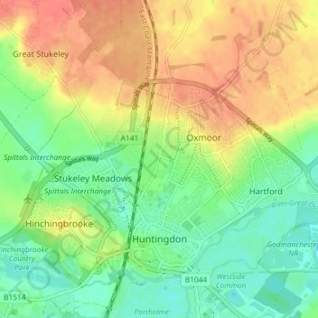
Nom : Carte topographique Huntingdon, altitude, relief.
Altitude moyenne : 25 m
Altitude minimum : 3 m
Altitude maximum : 49 m
Autres cartes topographiques
Cliquez sur une carte pour visualiser sa topographie, son altitude et son relief.
Old Weston
United Kingdom > England > Cambridgeshire > Huntingdonshire
Old Weston, Huntingdonshire, Cambridgeshire, East of England, England, United Kingdom
Altitude moyenne : 65 m
Godmanchester
United Kingdom > England > Cambridgeshire > Huntingdonshire > Godmanchester
Godmanchester, Huntingdonshire, Cambridgeshire, East of England, England, United Kingdom
Altitude moyenne : 22 m