
Faire un don
Équipez-vous pour votre prochaine aventure :
En tant que Partenaire Amazon, ce site perçoit une commission sur les achats éligibles sans surcoût pour vous.
Carte topographique Wheatley
Cliquez sur la carte pour afficher l’altitude.
Faire un don
Équipez-vous pour votre prochaine aventure :
En tant que Partenaire Amazon, ce site perçoit une commission sur les achats éligibles sans surcoût pour vous.
À propos de cette carte
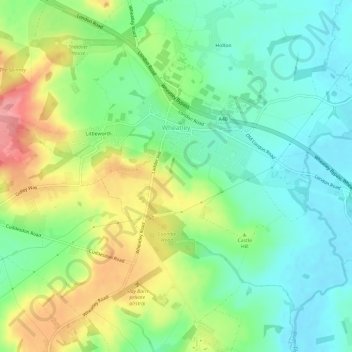
Nom : Carte topographique Wheatley, altitude, relief.
Altitude moyenne : 90 m
Altitude minimum : 52 m
Altitude maximum : 157 m
Faire un don
Équipez-vous pour votre prochaine aventure :
En tant que Partenaire Amazon, ce site perçoit une commission sur les achats éligibles sans surcoût pour vous.
Autres cartes topographiques
Cliquez sur une carte pour visualiser sa topographie, son altitude et son relief.
Harpsden Wood
United Kingdom > England > Oxfordshire > South Oxfordshire > Henley-on-Thames > Harpsden
Altitude moyenne : 63 m
Faire un don
Équipez-vous pour votre prochaine aventure :
En tant que Partenaire Amazon, ce site perçoit une commission sur les achats éligibles sans surcoût pour vous.
Kingwood Common
United Kingdom > England > Oxfordshire > South Oxfordshire > Highmoor
Altitude moyenne : 125 m
Waterperry
United Kingdom > England > Oxfordshire > South Oxfordshire > Waterstock
Altitude moyenne : 63 m
Faire un don
Équipez-vous pour votre prochaine aventure :
En tant que Partenaire Amazon, ce site perçoit une commission sur les achats éligibles sans surcoût pour vous.
Cane End
United Kingdom > England > Oxfordshire > South Oxfordshire > Gallowstree Common
Altitude moyenne : 108 m
Cowleaze Wood
United Kingdom > England > Oxfordshire > South Oxfordshire > Lewknor
Altitude moyenne : 209 m
Wittenham Clumps
United Kingdom > England > Oxfordshire > South Oxfordshire > Little Wittenham
Altitude moyenne : 65 m
Faire un don
Équipez-vous pour votre prochaine aventure :
En tant que Partenaire Amazon, ce site perçoit une commission sur les achats éligibles sans surcoût pour vous.
Mongewell
United Kingdom > England > Oxfordshire > South Oxfordshire > Crowmarsh Gifford
Altitude moyenne : 59 m
Sonning Eye
United Kingdom > England > Oxfordshire > South Oxfordshire > Dunsden Green > Sonning Eye
Altitude moyenne : 44 m
Preston Crowmarsh
United Kingdom > England > Oxfordshire > South Oxfordshire > Benson
Altitude moyenne : 58 m
Faire un don
Équipez-vous pour votre prochaine aventure :
En tant que Partenaire Amazon, ce site perçoit une commission sur les achats éligibles sans surcoût pour vous.
Ewelme Park
United Kingdom > England > Oxfordshire > South Oxfordshire > Swyncombe
Altitude moyenne : 172 m
Chalkhouse Green
United Kingdom > England > Oxfordshire > South Oxfordshire > Kidmore End
Altitude moyenne : 83 m
Faire un don
Équipez-vous pour votre prochaine aventure :
En tant que Partenaire Amazon, ce site perçoit une commission sur les achats éligibles sans surcoût pour vous.
Draycot
United Kingdom > England > Oxfordshire > South Oxfordshire > Tiddington
Altitude moyenne : 68 m
Wet n Wild Oxford
United Kingdom > England > Oxfordshire > South Oxfordshire > Berinsfield
Altitude moyenne : 51 m
Gatehampton
United Kingdom > England > Oxfordshire > South Oxfordshire > Goring-on-Thames
Altitude moyenne : 88 m
Faire un don
Équipez-vous pour votre prochaine aventure :
En tant que Partenaire Amazon, ce site perçoit une commission sur les achats éligibles sans surcoût pour vous.
Baldon Row
United Kingdom > England > Oxfordshire > South Oxfordshire > Toot Baldon
Altitude moyenne : 73 m
Little Haseley
United Kingdom > England > Oxfordshire > South Oxfordshire > Great Haseley
Altitude moyenne : 73 m
Newnham Murren
United Kingdom > England > Oxfordshire > South Oxfordshire > Crowmarsh Gifford
Altitude moyenne : 59 m
Faire un don
Équipez-vous pour votre prochaine aventure :
En tant que Partenaire Amazon, ce site perçoit une commission sur les achats éligibles sans surcoût pour vous.
Christmas Common
United Kingdom > England > Oxfordshire > South Oxfordshire > Watlington
Christmas Common is a hamlet in Watlington civil parish, Oxfordshire about 7+1⁄2 miles (12 km) south of Thame in Oxfordshire, close to the boundary with Buckinghamshire. The hamlet is 812 feet (247 m) above sea level on an escarpment of the Chiltern Hills. Because of its elevation, Christmas Common has two…
Altitude moyenne : 192 m
Faire un don
Équipez-vous pour votre prochaine aventure :
En tant que Partenaire Amazon, ce site perçoit une commission sur les achats éligibles sans surcoût pour vous.
Chinnor Quarry 2B
United Kingdom > England > Oxfordshire > South Oxfordshire > Kingston Blount > Crowell
Altitude moyenne : 163 m
Kingston Stert
United Kingdom > England > Oxfordshire > South Oxfordshire > Aston Rowant
Altitude moyenne : 96 m
Faire un don
Équipez-vous pour votre prochaine aventure :
En tant que Partenaire Amazon, ce site perçoit une commission sur les achats éligibles sans surcoût pour vous.
Woodperry
United Kingdom > England > Oxfordshire > South Oxfordshire > Stanton St John
Altitude moyenne : 89 m
Edmonds Park
United Kingdom > England > Oxfordshire > South Oxfordshire > Didcot > East Hagbourne
Altitude moyenne : 68 m
Overy
United Kingdom > England > Oxfordshire > South Oxfordshire > Dorchester-on-Thames
Altitude moyenne : 55 m
Faire un don
Équipez-vous pour votre prochaine aventure :
En tant que Partenaire Amazon, ce site perçoit une commission sur les achats éligibles sans surcoût pour vous.
Dorchester-on-Thames
United Kingdom > England > Oxfordshire > South Oxfordshire
Altitude moyenne : 54 m
Witheridge Hill
United Kingdom > England > Oxfordshire > South Oxfordshire > Highmoor > Witheridge Hill
Altitude moyenne : 144 m
Brookhampton
United Kingdom > England > Oxfordshire > South Oxfordshire > Chiselhampton > Brookhampton
Altitude moyenne : 59 m
Faire un don
Équipez-vous pour votre prochaine aventure :
En tant que Partenaire Amazon, ce site perçoit une commission sur les achats éligibles sans surcoût pour vous.
Path Hill
United Kingdom > England > Oxfordshire > South Oxfordshire > Whitchurch Hill
Altitude moyenne : 99 m
Burcot
United Kingdom > England > Oxfordshire > South Oxfordshire > Clifton Hampden
Altitude moyenne : 59 m
Faire un don
Équipez-vous pour votre prochaine aventure :
En tant que Partenaire Amazon, ce site perçoit une commission sur les achats éligibles sans surcoût pour vous.
Peppard Common
United Kingdom > England > Oxfordshire > South Oxfordshire > Rotherfield Peppard
Altitude moyenne : 108 m
Dorchester-on-Thames
United Kingdom > England > Oxfordshire > South Oxfordshire
Altitude moyenne : 54 m