
Carte topographique Kingwood Common
Cliquez sur la carte pour afficher l’altitude.
À propos de cette carte
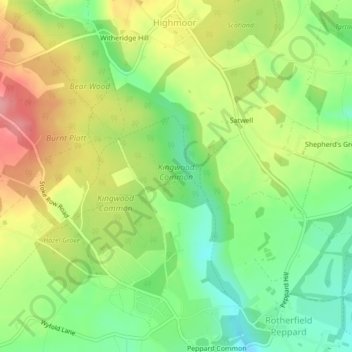
Nom : Carte topographique Kingwood Common, altitude, relief.
Altitude moyenne : 125 m
Altitude minimum : 77 m
Altitude maximum : 184 m
Autres cartes topographiques
Cliquez sur une carte pour visualiser sa topographie, son altitude et son relief.
Witheridge Hill
United Kingdom > England > Oxfordshire > South Oxfordshire > Highmoor > Witheridge Hill
Altitude moyenne : 144 m