
Carte topographique Apple Valley
Carte interactive
Cliquez sur la carte pour afficher l’altitude.
À propos de cette carte
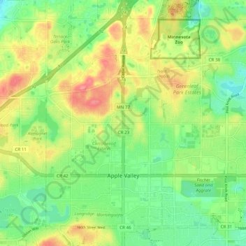
Nom : Carte topographique Apple Valley, altitude, relief.
Lieu : Apple Valley, Dakota County, Minnesota, 55124, United States (44.71734 -93.24835 44.77589 -93.15134)
Altitude moyenne : 301 m
Altitude minimum : 270 m
Altitude maximum : 343 m
According to the United States Census Bureau, the city has a total area of 17.57 square miles (45.51 km2), of which 16.86 square miles (43.67 km2) is land and 0.71 square miles (1.84 km2) is water. The city's geography is rolling, with elevation from the lowest to the highest points in the city varying by one hundred feet (thirty metres) or more. The downtown area and its adjacent residential district (which formed the original core of the city when it was incorporated) are in a shallow valley.
Autres cartes topographiques
Cliquez sur une carte pour visualiser sa topographie, son altitude et son relief.
West St. Paul
United States > Minnesota > Dakota County
West St. Paul, Dakota County, Minnesota, 55118, United States
Altitude moyenne : 294 m
Eagan
United States > Minnesota > Dakota County
Eagan, Dakota County, Minnesota, United States
Altitude moyenne : 267 m
Vermillion
United States > Minnesota > Dakota County
Vermillion, Dakota County, Minnesota, 55085, United States
Altitude moyenne : 260 m
Randolph
United States > Minnesota > Dakota County
Randolph, Dakota County, Minnesota, United States
Altitude moyenne : 270 m
Miesville
United States > Minnesota > Dakota County
Miesville, Dakota County, Minnesota, United States
Altitude moyenne : 289 m
Coates
United States > Minnesota > Dakota County
Coates, Dakota County, Minnesota, United States
Altitude moyenne : 280 m
Sunfish Lake
United States > Minnesota > Dakota County
Sunfish Lake, Dakota County, Minnesota, United States
Altitude moyenne : 287 m
Lilydale
United States > Minnesota > Dakota County
Lilydale, Dakota County, Minnesota, United States
Altitude moyenne : 257 m
Chimney Rock Scenic and Natural Area
United States > Minnesota > Dakota County
Chimney Rock Scenic and Natural Area, Joan Avenue, Marshan Township, Dakota County, Minnesota, United States
Altitude moyenne : 269 m
Waterford Township
United States > Minnesota > Dakota County
Waterford Township, Dakota County, Minnesota, United States
Altitude moyenne : 284 m
Etter
United States > Minnesota > Dakota County
Etter, Ravenna Township, Dakota County, Minnesota, United States
Altitude moyenne : 233 m
New Trier
United States > Minnesota > Dakota County
New Trier, Dakota County, Minnesota, United States
Altitude moyenne : 300 m
Hampton
United States > Minnesota > Dakota County
Hampton, Dakota County, Minnesota, 55031, United States
Altitude moyenne : 297 m
Carlson Lake
United States > Minnesota > Dakota County > Eagan
Carlson Lake, Eagan, Dakota County, Minnesota, United States
Altitude moyenne : 280 m
Burnsville
United States > Minnesota > Dakota County
Burnsville, Dakota County, Minnesota, United States
Altitude moyenne : 271 m
Mendota Heights
United States > Minnesota > Dakota County
Mendota Heights, Dakota County, Minnesota, 55120, United States
Altitude moyenne : 265 m
Empire
United States > Minnesota > Dakota County
Empire, Dakota County, Minnesota, United States
Altitude moyenne : 280 m
Hastings
United States > Minnesota > Dakota County
Hastings, Dakota County, Minnesota, 55033, United States
Altitude moyenne : 241 m
Lakeville
United States > Minnesota > Dakota County
Lakeville, Dakota County, Minnesota, 55044, United States
Altitude moyenne : 305 m
Inver Grove Heights
United States > Minnesota > Dakota County
Inver Grove Heights, Dakota County, Minnesota, United States
Altitude moyenne : 260 m
Farmington
United States > Minnesota > Dakota County > Farmington > Farmington
Farmington, Dakota County, Minnesota, 55024, United States
Altitude moyenne : 280 m
Waterford
United States > Minnesota > Dakota County > Waterford
Waterford, Dakota County, Minnesota, 55057, United States
Altitude moyenne : 289 m
Mendota
United States > Minnesota > Dakota County
Mendota, Dakota County, Minnesota, 55150, United States
Altitude moyenne : 242 m
Pig's Eye Island Heron Rookery SNA
United States > Minnesota > Dakota County > South St. Paul
Pig's Eye Island Heron Rookery SNA, Hardman Avenue North, South St. Paul, Dakota County, Minnesota, 55075, United States
Altitude moyenne : 221 m
Burnsville
United States > Minnesota > Dakota County > Burnsville > Burnsville
Burnsville, Dakota County, Minnesota, 55337, United States
Altitude moyenne : 275 m
Lakeville
United States > Minnesota > Dakota County > Lakeville > Lakeville
Lakeville, Dakota County, Minnesota, 55044, United States
Altitude moyenne : 306 m
Rosemount
United States > Minnesota > Dakota County
Rosemount, Dakota County, Minnesota, 55068, United States
Altitude moyenne : 287 m
Farmington
United States > Minnesota > Dakota County
Farmington, Dakota County, Minnesota, 55024, United States
Altitude moyenne : 280 m
South Saint Paul
United States > Minnesota > Dakota County
South Saint Paul, Dakota County, Minnesota, 55075, United States
Altitude moyenne : 257 m