
Carte topographique Karns
Cliquez sur la carte pour afficher l’altitude.
Karns
Karns is located in the Beaver Creek Valley between Beaver Ridge and Copper Ridge, both of which are elongate ridges typical of the Ridge-and-Valley Appalachians. The center of the community is located at 35°58′55″N 84°06′50″W / 35.98194°N 84.11389°W / 35.98194; -84.11389 (35.982, -84.114). Elevation ranges from about 960 to 1,000 feet (300 m) above sea level. Beaver Creek, a tributary of the Clinch River, flows through the community.
À propos de cette carte
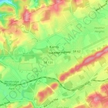
Nom : Carte topographique Karns, altitude, relief.
Altitude moyenne : 314 m
Altitude minimum : 246 m
Altitude maximum : 394 m
Autres cartes topographiques
Cliquez sur une carte pour visualiser sa topographie, son altitude et son relief.
Audubon Hills
United States > Tennessee > Knox County > Farragut > Audubon Hills
Altitude moyenne : 270 m
Highland Park
United States > Tennessee > Knox County > Knoxville > Highland Park
Altitude moyenne : 341 m
Island Home
United States > Tennessee > Knox County > Knoxville > Island Home
Altitude moyenne : 276 m