
Faire un don
Équipez-vous pour votre prochaine aventure :
En tant que Partenaire Amazon, ce site perçoit une commission sur les achats éligibles sans surcoût pour vous.
Carte topographique Dorrery
Cliquez sur la carte pour afficher l’altitude.
Faire un don
Équipez-vous pour votre prochaine aventure :
En tant que Partenaire Amazon, ce site perçoit une commission sur les achats éligibles sans surcoût pour vous.
À propos de cette carte
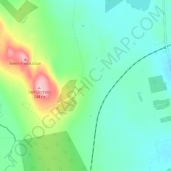
Nom : Carte topographique Dorrery, altitude, relief.
Lieu : Dorrery, Highland, Scotland, KW12 6YW, United Kingdom (58.45391 -3.60744 58.49391 -3.56744)
Altitude moyenne : 108 m
Altitude minimum : 60 m
Altitude maximum : 245 m
Faire un don
Équipez-vous pour votre prochaine aventure :
En tant que Partenaire Amazon, ce site perçoit une commission sur les achats éligibles sans surcoût pour vous.
Autres cartes topographiques
Cliquez sur une carte pour visualiser sa topographie, son altitude et son relief.
Skye
United Kingdom > Scotland > Highland
Beyond Loch Snizort to the west of Trotternish is the Waternish peninsula, which ends in Ardmore Point's double rock arch. Duirinish peninsula is separated from Waternish by Loch Dunvegan, which contains the island of Isay. It is ringed by sea cliffs that reach 296 metres (971 feet) on the west at Waterstein…
Altitude moyenne : 63 m
Faire un don
Équipez-vous pour votre prochaine aventure :
En tant que Partenaire Amazon, ce site perçoit une commission sur les achats éligibles sans surcoût pour vous.
Invergarry Castle
United Kingdom > Scotland > Highland > Invergarry
The survey drawing shows a plan and elevations of the castle, called the 'Castle of Glangary' on the drawing. The drawing may appear misleading, as more than one facade is joined together, but by cross-referencing the lettering on the plan to the elevations the appearance can be judged.
Altitude moyenne : 150 m
Faire un don
Équipez-vous pour votre prochaine aventure :
En tant que Partenaire Amazon, ce site perçoit une commission sur les achats éligibles sans surcoût pour vous.
Faire un don
Équipez-vous pour votre prochaine aventure :
En tant que Partenaire Amazon, ce site perçoit une commission sur les achats éligibles sans surcoût pour vous.
Beinn Eighe
United Kingdom > Scotland > Highland
Beinn Eighe (Scottish Gaelic for 'file mountain') is a mountain massif in the Torridon area of Wester Ross in the Northwest Highlands of Scotland. Lying south of Loch Maree, it forms a long ridge with many spurs and summits, two of which are classified as Munros: Ruadh-stac Mòr at 1,010 m (3,314 ft) and…
Altitude moyenne : 633 m
Faire un don
Équipez-vous pour votre prochaine aventure :
En tant que Partenaire Amazon, ce site perçoit une commission sur les achats éligibles sans surcoût pour vous.
Faire un don
Équipez-vous pour votre prochaine aventure :
En tant que Partenaire Amazon, ce site perçoit une commission sur les achats éligibles sans surcoût pour vous.
Faire un don
Équipez-vous pour votre prochaine aventure :
En tant que Partenaire Amazon, ce site perçoit une commission sur les achats éligibles sans surcoût pour vous.
Faire un don
Équipez-vous pour votre prochaine aventure :
En tant que Partenaire Amazon, ce site perçoit une commission sur les achats éligibles sans surcoût pour vous.
Faire un don
Équipez-vous pour votre prochaine aventure :
En tant que Partenaire Amazon, ce site perçoit une commission sur les achats éligibles sans surcoût pour vous.
Faire un don
Équipez-vous pour votre prochaine aventure :
En tant que Partenaire Amazon, ce site perçoit une commission sur les achats éligibles sans surcoût pour vous.
Faire un don
Équipez-vous pour votre prochaine aventure :
En tant que Partenaire Amazon, ce site perçoit une commission sur les achats éligibles sans surcoût pour vous.
Faire un don
Équipez-vous pour votre prochaine aventure :
En tant que Partenaire Amazon, ce site perçoit une commission sur les achats éligibles sans surcoût pour vous.
Faire un don
Équipez-vous pour votre prochaine aventure :
En tant que Partenaire Amazon, ce site perçoit une commission sur les achats éligibles sans surcoût pour vous.
Isle of Rum
United Kingdom > Scotland > Highland > Kinloch
The island's relief is spectacular, a 19th-century commentator remarking that "the interior is one heap of rude mountains, scarcely possessing an acre of level land". This combination of geology and topography make for less than ideal agricultural conditions, and it is doubtful that more than one tenth of the…
Altitude moyenne : 118 m
Faire un don
Équipez-vous pour votre prochaine aventure :
En tant que Partenaire Amazon, ce site perçoit une commission sur les achats éligibles sans surcoût pour vous.
Culloden Battlefield
United Kingdom > Scotland > Highland > Newlands of Culloden > Leanach
Since 2001, the site of the battle has undergone topographic, geophysical and metal detector surveys in addition to archaeological excavations. Interesting finds have been made in the areas on which the fiercest fighting occurred on the government left wing, particularly where Barrell's and Dejean's regiments…
Altitude moyenne : 141 m
Faire un don
Équipez-vous pour votre prochaine aventure :
En tant que Partenaire Amazon, ce site perçoit une commission sur les achats éligibles sans surcoût pour vous.
Faire un don
Équipez-vous pour votre prochaine aventure :
En tant que Partenaire Amazon, ce site perçoit une commission sur les achats éligibles sans surcoût pour vous.
Dunvegan Castle
United Kingdom > Scotland > Highland > Dunvegan > Totachocaire
Altitude moyenne : 41 m
Faire un don
Équipez-vous pour votre prochaine aventure :
En tant que Partenaire Amazon, ce site perçoit une commission sur les achats éligibles sans surcoût pour vous.
Faire un don
Équipez-vous pour votre prochaine aventure :
En tant que Partenaire Amazon, ce site perçoit une commission sur les achats éligibles sans surcoût pour vous.
Ardnamurchan
United Kingdom > Scotland > Highland
The north western corner of Ardnamurchan consists of a lopolith (previously interpreted as a ring dyke) that has been exposed at the surface. Evidence for such a structure can be identified from the phenocrysts in the rock exposures around the area of interest which show plagioclase crystals aligned towards…
Altitude moyenne : 73 m
Faire un don
Équipez-vous pour votre prochaine aventure :
En tant que Partenaire Amazon, ce site perçoit une commission sur les achats éligibles sans surcoût pour vous.
Faire un don
Équipez-vous pour votre prochaine aventure :
En tant que Partenaire Amazon, ce site perçoit une commission sur les achats éligibles sans surcoût pour vous.
Faire un don
Équipez-vous pour votre prochaine aventure :
En tant que Partenaire Amazon, ce site perçoit une commission sur les achats éligibles sans surcoût pour vous.
Loch Morar
United Kingdom > Scotland > Highland > Morar
Loch Morar (Scottish Gaelic: Loch Mòrair) is a freshwater loch in Lochaber, Highland, Scotland. It is the fifth-largest loch by surface area in Scotland, at 26.7 km2 (10.3 sq mi), and the deepest freshwater body in the British Isles with a maximum depth of 310 m (1,017 ft). The loch was created by glacial…
Altitude moyenne : 118 m
Faire un don
Équipez-vous pour votre prochaine aventure :
En tant que Partenaire Amazon, ce site perçoit une commission sur les achats éligibles sans surcoût pour vous.
Faire un don
Équipez-vous pour votre prochaine aventure :
En tant que Partenaire Amazon, ce site perçoit une commission sur les achats éligibles sans surcoût pour vous.
Faire un don
Équipez-vous pour votre prochaine aventure :
En tant que Partenaire Amazon, ce site perçoit une commission sur les achats éligibles sans surcoût pour vous.
Loch Affric
United Kingdom > Scotland > Highland
A number of smaller lochs surround Loch Affric. At the southwestern end sits Loch Coulavie located at the base An Tudair Beag and a slightly higher elevation. Also, at the southwestern end, the river Affric flows into the tiny loch of Loch na Camaig. At the northeastern side, Loch Pollan Fearna drains into…
Altitude moyenne : 477 m
Faire un don
Équipez-vous pour votre prochaine aventure :
En tant que Partenaire Amazon, ce site perçoit une commission sur les achats éligibles sans surcoût pour vous.
Faire un don
Équipez-vous pour votre prochaine aventure :
En tant que Partenaire Amazon, ce site perçoit une commission sur les achats éligibles sans surcoût pour vous.