
Carte topographique Burks Hill
Carte interactive
Cliquez sur la carte pour afficher l’altitude.
À propos de cette carte
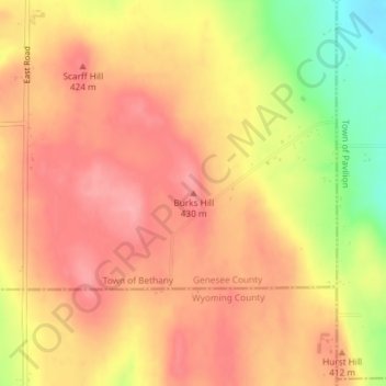
Nom : Carte topographique Burks Hill, altitude, relief.
Lieu : Burks Hill, Genesee County, New York, USA (42.87668 -78.08784 42.87678 -78.08774)
Altitude moyenne : 398 m
Altitude minimum : 327 m
Altitude maximum : 434 m
Autres cartes topographiques
Cliquez sur une carte pour visualiser sa topographie, son altitude et son relief.
Harlem
USA > New York > New York City
Harlem, Manhattan, Manhattan Community Board 10, New York County, New York City, New York, USA
Altitude moyenne : 16 m
Rikers Island
USA > New York > New York City
Rikers Island, Bronx County, New York City, New York, USA
Altitude moyenne : 2 m
Wright Island
USA > New York > New Rochelle
Wright Island, New Rochelle, Westchester County, New York, 10805, USA
Altitude moyenne : 45 m
Ebenezer
USA > New York > West Seneca > Ebenezer
Ebenezer, West Seneca, Erie County, New York, 14224, USA
Altitude moyenne : 201 m
Fostertown
USA > New York > Fostertown
Fostertown, Town of Newburgh, Orange County, New York, 12560, USA
Altitude moyenne : 145 m
Big Bear Mountain
Big Bear Mountain, Town of Johnsburg, Warren County, New York, USA
Altitude moyenne : 616 m
Mount Warren
Mount Warren, Town of Bovina, Delaware County, New York, USA
Altitude moyenne : 677 m
Livingston Island
Livingston Island, Town of Philipstown, Putnam County, New York, 10922, USA
Altitude moyenne : 156 m
Flat Top Mountain
Flat Top Mountain, Franklin County, New York, USA
Altitude moyenne : 568 m
Lake Surprise
USA > New York > North Highland
Lake Surprise, Lake Surprise Road, North Highland, Town of Philipstown, Putnam County, New York, 10516, USA
Altitude moyenne : 256 m
Soft Maple
USA > New York > Soft Maple
Soft Maple, Lewis County, New York, USA
Altitude moyenne : 397 m
Eden Valley
USA > New York > Eden Valley
Eden Valley, Erie County, New York, 14057, USA
Altitude moyenne : 246 m
Sawtooth Mountains
Sawtooth Mountains, Franklin County, New York, USA
Altitude moyenne : 927 m
Green's Creek
Green's Creek, West Sayville, Suffolk County, New York, 11796, USA
Altitude moyenne : 4 m
Crystal Creek
Crystal Creek, Lewis County, New York, 13367, USA
Altitude moyenne : 242 m
Chinatown
USA > New York > New York City
Chinatown, Manhattan, Manhattan Community Board 2, New York County, New York City, New York, USA
Altitude moyenne : 12 m
Skull Island
USA > New York > Speculator
Skull Island, Speculator, Town of Lake Pleasant, Hamilton County, New York, USA
Altitude moyenne : 575 m
Downsville
USA > New York > Downsville
Downsville, Town of Colchester, Delaware County, New York, 13755, USA
Altitude moyenne : 454 m
Town of DeWitt
USA > New York > Town of DeWitt
DeWitt, Town of DeWitt, Onondaga County, New York, 13214, USA
Altitude moyenne : 161 m
Jordan River
Jordan River, Saint Lawrence County, New York, USA
Altitude moyenne : 479 m
Natural Bridge
USA > New York > Natural Bridge
Natural Bridge, Jefferson County, New York, 13665, USA
Altitude moyenne : 250 m
Governors Island
USA > New York > New York City
Governors Island, Manhattan Community Board 1, New York County, New York City, New York, USA
Altitude moyenne : 1 m
Fly Island
USA > New York > Lloyd Harbor
Fly Island, Lloyd Harbor, Suffolk County, New York, USA
Altitude moyenne : 38 m
Avalanche Lake
Avalanche Lake, Avalanche Pass Trail, Essex County, New York, USA
Altitude moyenne : 1’066 m