
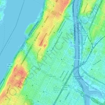
Carte topographique Harlem
Carte interactive
Cliquez sur la carte pour afficher l’altitude.
À propos de cette carte
Nom : Carte topographique Harlem, altitude, relief.
Altitude moyenne : 16 m
Altitude minimum : -3 m
Altitude maximum : 61 m
Autres cartes topographiques
Cliquez sur une carte pour visualiser sa topographie, son altitude et son relief.
Rikers Island
USA > New York > New York City
Rikers Island, Bronx County, New York City, New York, USA
Altitude moyenne : 2 m
Chinatown
USA > New York > New York City
Chinatown, Manhattan, Manhattan Community Board 2, New York County, New York City, New York, USA
Altitude moyenne : 12 m
Governors Island
USA > New York > New York City
Governors Island, Manhattan Community Board 1, New York County, New York City, New York, USA
Altitude moyenne : 1 m