
Carte topographique Poole
Cliquez sur la carte pour afficher l’altitude.
À propos de cette carte
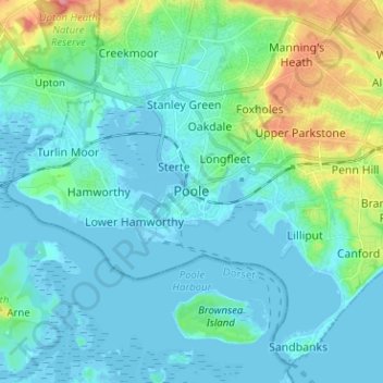
Nom : Carte topographique Poole, altitude, relief.
Altitude moyenne : 16 m
Altitude minimum : -7 m
Altitude maximum : 87 m
Autres cartes topographiques
Cliquez sur une carte pour visualiser sa topographie, son altitude et son relief.
Christchurch
United Kingdom > England > Bournemouth, Christchurch and Poole > Hurn
Altitude moyenne : 18 m
East Parley Common
United Kingdom > England > Bournemouth, Christchurch and Poole > Hurn
Altitude moyenne : 13 m
Upton Heath Nature Reserve
United Kingdom > England > Bournemouth, Christchurch and Poole > Poole
Altitude moyenne : 40 m
Redhill Park
United Kingdom > England > Bournemouth, Christchurch and Poole > Bournemouth > Talbot Village
Altitude moyenne : 33 m
Hamworthy Park
United Kingdom > England > Bournemouth, Christchurch and Poole > Poole
Altitude moyenne : 2 m
Kings Park
United Kingdom > England > Bournemouth, Christchurch and Poole > Bournemouth
Altitude moyenne : 31 m
Christchurch
United Kingdom > England > Bournemouth, Christchurch and Poole > Christchurch
Altitude moyenne : 8 m
Christchurch
United Kingdom > England > Bournemouth, Christchurch and Poole > Christchurch
Altitude moyenne : 18 m
Christchurch
United Kingdom > England > Bournemouth, Christchurch and Poole > Hurn
Altitude moyenne : 18 m
Island in the Stour
United Kingdom > England > Bournemouth, Christchurch and Poole > Poole > Merley
Altitude moyenne : 28 m
Christchurch
United Kingdom > England > Bournemouth, Christchurch and Poole > Hurn
Altitude moyenne : 18 m