
Carte topographique Hurn
Cliquez sur la carte pour afficher l’altitude.
À propos de cette carte
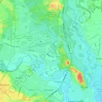
Nom : Carte topographique Hurn, altitude, relief.
Altitude moyenne : 12 m
Altitude minimum : -1 m
Altitude maximum : 54 m
Autres cartes topographiques
Cliquez sur une carte pour visualiser sa topographie, son altitude et son relief.
East Parley Common
United Kingdom > England > Bournemouth, Christchurch and Poole > Hurn
Altitude moyenne : 13 m
Highcliffe-on-Sea
United Kingdom > England > Bournemouth, Christchurch and Poole
Altitude moyenne : 19 m
Hengistbury Head
United Kingdom > England > Bournemouth, Christchurch and Poole > Bournemouth
In 1910 the first international aviation meeting ever held in Britain took place on a specially laid out aerodrome consisting of a mile of grassland between the "Double Dykes" and the nearby village of Tuckton. About twenty pioneer aviators from around the world participated in various competitions including…
Altitude moyenne : 0 m
Throop
United Kingdom > England > Bournemouth, Christchurch and Poole > Bournemouth
Altitude moyenne : 13 m
Kinson
United Kingdom > England > Bournemouth, Christchurch and Poole > Bournemouth
Altitude moyenne : 26 m
Upton Heath Nature Reserve
United Kingdom > England > Bournemouth, Christchurch and Poole > Poole
Altitude moyenne : 40 m
Bear Cross
United Kingdom > England > Bournemouth, Christchurch and Poole > Bournemouth
Altitude moyenne : 30 m
St Catherine's Hill
United Kingdom > England > Bournemouth, Christchurch and Poole > Christchurch
Altitude moyenne : 10 m
Redhill Park
United Kingdom > England > Bournemouth, Christchurch and Poole > Bournemouth > Talbot Village
Altitude moyenne : 33 m
Hamworthy Park
United Kingdom > England > Bournemouth, Christchurch and Poole > Poole
Altitude moyenne : 2 m
Kings Park
United Kingdom > England > Bournemouth, Christchurch and Poole > Bournemouth
Altitude moyenne : 31 m
Holes Bay
United Kingdom > England > Bournemouth, Christchurch and Poole > Poole
Altitude moyenne : 4 m
Island in the Stour
United Kingdom > England > Bournemouth, Christchurch and Poole > Poole > Merley
Altitude moyenne : 28 m
Holdenhurst
United Kingdom > England > Bournemouth, Christchurch and Poole > Bournemouth
Altitude moyenne : 12 m
Kinson
United Kingdom > England > Bournemouth, Christchurch and Poole > Bournemouth
Altitude moyenne : 26 m