
Carte topographique Aberdeen
Carte interactive
Cliquez sur la carte pour afficher l’altitude.
À propos de cette carte
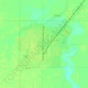
Nom : Carte topographique Aberdeen, altitude, relief.
Lieu : Aberdeen, Bingham County, Idaho, 83210, United States (42.93691 -112.84870 42.95138 -112.82435)
Altitude moyenne : 1’341 m
Altitude minimum : 1’332 m
Altitude maximum : 1’345 m
Aberdeen is located at 42°56′36″N 112°50′22″W / 42.94333°N 112.83944°W / 42.94333; -112.83944 (42.943405, -112.839322), at an elevation of 4,403 feet (1,342 m) above sea level. According to the United States Census Bureau, the city has a total area of 1.03 square miles (2.67 km2), all of it land.
Autres cartes topographiques
Cliquez sur une carte pour visualiser sa topographie, son altitude et son relief.
Blackfoot
United States > Idaho > Bingham County
Blackfoot, Bingham County, Idaho, 83221, United States
Altitude moyenne : 1’371 m
Atomic City
United States > Idaho > Bingham County
Atomic City, Bingham County, Idaho, 83215, United States
Altitude moyenne : 1’533 m
Fort Hall
United States > Idaho > Bingham County
Fort Hall, Bingham County, Idaho, 83203, United States
Altitude moyenne : 1’356 m