
Carte topographique Hamilton's Lock
Carte interactive
Cliquez sur la carte pour afficher l’altitude.
À propos de cette carte
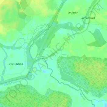
Nom : Carte topographique Hamilton's Lock, altitude, relief.
Altitude moyenne : 35 m
Altitude minimum : 26 m
Altitude maximum : 43 m
Autres cartes topographiques
Cliquez sur une carte pour visualiser sa topographie, son altitude et son relief.
Burrow
Burrow, Kilcumeragh ED, The Municipal District of Tullamore, County Offaly, Leinster, Ireland
Altitude moyenne : 64 m
Mount Lucas
Mount Lucas, Esker ED, The Municipal District of Edenderry, County Offaly, Leinster, R35 XW10, Ireland
Altitude moyenne : 76 m
Ballintogher
Ballintogher, Rathfeston ED, The Municipal District of Edenderry, County Offaly, Leinster, Ireland
Altitude moyenne : 86 m
Coleraine
Coleraine, Silverbrook ED, The Municipal District of Tullamore, County Offaly, Leinster, Ireland
Altitude moyenne : 59 m
Edenderry
Edenderry, The Municipal District of Edenderry, County Offaly, Leinster, Ireland
Altitude moyenne : 74 m
The Municipal District of Birr
The Municipal District of Birr, County Offaly, Leinster, Ireland
Altitude moyenne : 97 m
The Municipal District of Edenderry
The Municipal District of Edenderry, County Offaly, Leinster, Ireland
Altitude moyenne : 80 m
Kinnity
Ireland > County Offaly > The Municipal District of Birr
Kinnity, The Municipal District of Birr, County Offaly, Leinster, Ireland
Altitude moyenne : 251 m
Tullamore
Tullamore, Tullamore Urban ED, The Municipal District of Tullamore, County Offaly, Leinster, R35 P761, Ireland
Altitude moyenne : 63 m
Carrig Bridge
Ireland > County Offaly > The Municipal District of Birr
Carrig Bridge, Seirkieran ED, The Municipal District of Birr, County Offaly, Leinster, R42 W542, Ireland
Altitude moyenne : 84 m
Shinrone
Ireland > County Offaly > The Municipal District of Birr > Shinrone
Shinrone, The Municipal District of Birr, County Offaly, Leinster, Ireland
Altitude moyenne : 72 m
Road
Road, Ballyburly ED, The Municipal District of Edenderry, County Offaly, Leinster, Ireland
Altitude moyenne : 87 m
Banagher
Ireland > County Offaly > Banagher
Banagher, The Municipal District of Birr, County Offaly, Leinster, R42 DE61, Ireland
Altitude moyenne : 43 m
Daingean
Ireland > County Offaly > Daingean
Daingean, The Municipal District of Edenderry, County Offaly, Leinster, Ireland
Altitude moyenne : 82 m
Down
Down, Clonygowan ED, The Municipal District of Edenderry, County Offaly, Leinster, Ireland
Altitude moyenne : 88 m