
Carte topographique Joshimath
Cliquez sur la carte pour afficher l’altitude.
À propos de cette carte
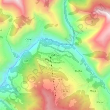
Nom : Carte topographique Joshimath, altitude, relief.
Lieu : Joshimath, Joshimath Tehsil, Chamoli, Uttarakhand, India (30.51558 79.52126 30.59558 79.60126)
Altitude moyenne : 2’272 m
Altitude minimum : 1’326 m
Altitude maximum : 3’573 m
Autres cartes topographiques
Cliquez sur une carte pour visualiser sa topographie, son altitude et son relief.
Valley of Flowers National Park
India > Uttarakhand > Joshimath Tehsil > Ghangaria
Altitude moyenne : 4’606 m
Valley of Flowers National Park
India > Uttarakhand > Joshimath Tehsil > Ghangaria
Altitude moyenne : 4’606 m