
Faire un don
Équipez-vous pour votre prochaine aventure :
En tant que Partenaire Amazon, ce site perçoit une commission sur les achats éligibles sans surcoût pour vous.
Carte topographique Mek'elē
Cliquez sur la carte pour afficher l’altitude.
Faire un don
Équipez-vous pour votre prochaine aventure :
En tant que Partenaire Amazon, ce site perçoit une commission sur les achats éligibles sans surcoût pour vous.
Mek'elē
Mekelle (Tigrinya: መቐለ), or Mekele, is a special zone and capital of the Tigray Region of Ethiopia. Mekelle was formerly the capital of Enderta awraja in Tigray. It is located around 780 kilometres (480 mi) north of the Ethiopian capital Addis Ababa, with an elevation of 2,254 metres (7,395 ft) above sea level. Administratively, Mekelle is considered a Special Zone, which is divided into seven sub-cities. It is the economic, cultural, and political hub of northern Ethiopia.
Faire un don
Équipez-vous pour votre prochaine aventure :
En tant que Partenaire Amazon, ce site perçoit une commission sur les achats éligibles sans surcoût pour vous.
À propos de cette carte
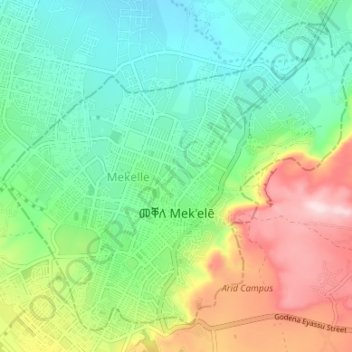
Nom : Carte topographique Mek'elē, altitude, relief.
Lieu : Mek'elē, Tigray, Ethiopia (13.47492 39.44380 13.53166 39.51051)
Altitude moyenne : 2’090 m
Altitude minimum : 1’969 m
Altitude maximum : 2’330 m
Faire un don
Équipez-vous pour votre prochaine aventure :
En tant que Partenaire Amazon, ce site perçoit une commission sur les achats éligibles sans surcoût pour vous.
Autres cartes topographiques
Cliquez sur une carte pour visualiser sa topographie, son altitude et son relief.
Mekoni
Mekoni, also Mehoni (Ge'ez: መኾኒ or መሆኒ), is a town in the Tigray Region of Ethiopia. "Mekoni" (pronounced as 'Me-koni') is located at 657 km north of Addis Ababa along Ethiopian Highway 2 which runs to Mekelle (the capital city of Tigray region), Adigrat, Aksum, Shire and Humera with an altitude of 2479 m.
Altitude moyenne : 1’806 m
Faire un don
Équipez-vous pour votre prochaine aventure :
En tant que Partenaire Amazon, ce site perçoit une commission sur les achats éligibles sans surcoût pour vous.
Abiy Addi
Abiy Addi has an elevation ranging from 1917 to 2275 meters above sea level. From the higher to the lower locations, the following geological formations are present: Ashangi Basalts, Amba Aradam Formation, Adigrat Sandstone, and Edaga Arbi Glacials.
Altitude moyenne : 1’957 m
Hagere Selam
Hagere Selam (Tigrinya: ሃገረ ሰላም) is a town in northern Ethiopia. Located on the Mekelle-Abiy Addi regional road, it is located at an elevation of 2650 metres above sea level. The town is the administrative center of the Dogu'a Tembien woreda. The weekly market is on Saturdays.
Altitude moyenne : 2’446 m
Faire un don
Équipez-vous pour votre prochaine aventure :
En tant que Partenaire Amazon, ce site perçoit une commission sur les achats éligibles sans surcoût pour vous.
Faire un don
Équipez-vous pour votre prochaine aventure :
En tant que Partenaire Amazon, ce site perçoit une commission sur les achats éligibles sans surcoût pour vous.
Rama
Rama (also called Mai Lala, Lala) is a town in Tigray, Ethiopia. It is located 35 km north of the town of Adwa and 7 kilometers from the border with Eritrea, in the Mehakelegnaw (Central) Zone of the Tigray Region. The town occupies a fertile lowland area and has a latitude and longitude of 14°25′N…
Altitude moyenne : 1’429 m
Faire un don
Équipez-vous pour votre prochaine aventure :
En tant que Partenaire Amazon, ce site perçoit une commission sur les achats éligibles sans surcoût pour vous.
Faire un don
Équipez-vous pour votre prochaine aventure :
En tant que Partenaire Amazon, ce site perçoit une commission sur les achats éligibles sans surcoût pour vous.
Faire un don
Équipez-vous pour votre prochaine aventure :
En tant que Partenaire Amazon, ce site perçoit une commission sur les achats éligibles sans surcoût pour vous.
Faire un don
Équipez-vous pour votre prochaine aventure :
En tant que Partenaire Amazon, ce site perçoit une commission sur les achats éligibles sans surcoût pour vous.
Freweyni
Freweyni (also known as Sinkata or ferawun) is a town in northern Ethiopia. Located 80 kilometers north of Mekele in the Misraqawi Zone of the Tigray Region (or kilil) of Ethiopia, this town has a latitude and longitude of 14°3′N 39°34′E / 14.050°N 39.567°E / 14.050; 39.567 with an elevation…
Altitude moyenne : 2’471 m
Adwa
Adwa (Tigrinya: ዓድዋ; Amharic: ዐድዋ; also spelled Adowa or Aduwa) is a town and separate woreda in Tigray Region, Ethiopia. It is best known as the community closest to the site of the 1896 Battle of Adwa, in which Ethiopian soldiers defeated Italian troops, thus being one of the few African nations…
Altitude moyenne : 1’962 m
Humera
Humera (Tigrinya: ሑመራ; Amharic: ሁመራ) is a town in the Kafta Humera woreda in the Tigray Region of Ethiopia. Located in the Western Zone the town has an elevation of 585 metres (1,919 ft) above sea level. The Tekezé river borders the town to the north. Humera is a very important regional…
Altitude moyenne : 594 m
Faire un don
Équipez-vous pour votre prochaine aventure :
En tant que Partenaire Amazon, ce site perçoit une commission sur les achats éligibles sans surcoût pour vous.
Faire un don
Équipez-vous pour votre prochaine aventure :
En tant que Partenaire Amazon, ce site perçoit une commission sur les achats éligibles sans surcoût pour vous.
Alamata
Alamata (Tigrinya: ኣላማጣ ) is a town in the Tigray Region of Ethiopia. Located in the Debubawi (Southern) zone of Tigray it has a latitude and longitude of 12°25′N 39°33′E / 12.417°N 39.550°E / 12.417; 39.550 and an elevation of 1,520 metres (4,990 ft) above sea level and is located…
Altitude moyenne : 1’574 m
Faire un don
Équipez-vous pour votre prochaine aventure :
En tant que Partenaire Amazon, ce site perçoit une commission sur les achats éligibles sans surcoût pour vous.
Adwa
Adwa (Tigrinya: ዓድዋ; Amharic: ዐድዋ; also spelled Adowa or Aduwa) is a town and separate woreda in Tigray Region, Ethiopia. It is best known as the community closest to the site of the 1896 Battle of Adwa, in which Ethiopian soldiers defeated Italian troops, thus being one of the few African nations…
Altitude moyenne : 1’962 m
Faire un don
Équipez-vous pour votre prochaine aventure :
En tant que Partenaire Amazon, ce site perçoit une commission sur les achats éligibles sans surcoût pour vous.
Adigrat
Adigrat (Tigrinya: ዓዲግራት, ʿaddigrat, also called ʿAddi Grat) is a city and separate woreda in Tigray Region of Ethiopia. It is located in the Misraqawi Zone at longitude and latitude 14°16′N 39°27′E / 14.267°N 39.450°E / 14.267; 39.450Coordinates: 14°16′N 39°27′E /…
Altitude moyenne : 2’557 m
Abiy Addi
Abiy Addi has an elevation ranging from 1917 to 2275 meters above sea level. From the higher to the lower locations, the following geological formations are present: Ashangi Basalts, Amba Aradam Formation, Adigrat Sandstone, and Edaga Arbi Glacials.
Altitude moyenne : 1’957 m
Faire un don
Équipez-vous pour votre prochaine aventure :
En tant que Partenaire Amazon, ce site perçoit une commission sur les achats éligibles sans surcoût pour vous.
Adigrat
Adigrat (Tigrinya: ዓዲግራት, ʿaddigrat, also called ʿAddi Grat) is a city and separate woreda in Tigray Region of Ethiopia. It is located in the Misraqawi Zone at longitude and latitude 14°16′N 39°27′E / 14.267°N 39.450°E / 14.267; 39.450Coordinates: 14°16′N 39°27′E /…
Altitude moyenne : 2’557 m