
Faire un don
Équipez-vous pour votre prochaine aventure :
En tant que Partenaire Amazon, ce site perçoit une commission sur les achats éligibles sans surcoût pour vous.
Carte topographique Adwa
Cliquez sur la carte pour afficher l’altitude.
Faire un don
Équipez-vous pour votre prochaine aventure :
En tant que Partenaire Amazon, ce site perçoit une commission sur les achats éligibles sans surcoût pour vous.
Adwa
Adwa (Tigrinya: ዓድዋ; Amharic: ዐድዋ; also spelled Adowa or Aduwa) is a town and separate woreda in Tigray Region, Ethiopia. It is best known as the community closest to the site of the 1896 Battle of Adwa, in which Ethiopian soldiers defeated Italian troops, thus being one of the few African nations to thwart European colonialism. Located in the Central Zone of the Tigray Region, Adwa has a longitude and latitude of 14°10′N 38°54′E / 14.167°N 38.900°E / 14.167; 38.900, and an elevation of 1907 meters. Adwa is surrounded by Adwa woreda.
Faire un don
Équipez-vous pour votre prochaine aventure :
En tant que Partenaire Amazon, ce site perçoit une commission sur les achats éligibles sans surcoût pour vous.
À propos de cette carte
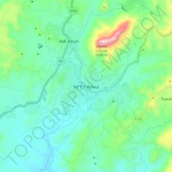
Nom : Carte topographique Adwa, altitude, relief.
Lieu : Adwa, Central Tigray, Tigray, Ethiopia (14.12707 38.85116 14.20707 38.93116)
Altitude moyenne : 1’962 m
Altitude minimum : 1’821 m
Altitude maximum : 2’460 m
Faire un don
Équipez-vous pour votre prochaine aventure :
En tant que Partenaire Amazon, ce site perçoit une commission sur les achats éligibles sans surcoût pour vous.
Autres cartes topographiques
Cliquez sur une carte pour visualiser sa topographie, son altitude et son relief.
Mek'elē
Mekelle (Tigrinya: መቐለ), or Mek'ele, is a special zone and capital of the Tigray Region of Ethiopia. Mekelle was formerly the capital of Enderta awraja in Tigray. It is located around 780 kilometres (480 mi) north of the Ethiopian capital Addis Ababa, with an elevation of 2,254 metres (7,395 ft) above…
Altitude moyenne : 2’090 m
Mek'elē
Mekelle (Tigrinya: መቐለ), or Mekele, is a special zone and capital of the Tigray Region of Ethiopia. Mekelle was formerly the capital of Enderta awraja in Tigray. It is located around 780 kilometres (480 mi) north of the Ethiopian capital Addis Ababa, with an elevation of 2,254 metres (7,395 ft) above sea…
Altitude moyenne : 2’090 m
Alamata
Alamata (Tigrinya: ኣላማጣ ) is a town in the Tigray Region of Ethiopia. Located in the Debubawi (Southern) zone of Tigray it has a latitude and longitude of 12°25′N 39°33′E / 12.417°N 39.550°E / 12.417; 39.550 and an elevation of 1,520 metres (4,990 ft) above sea level and is located…
Altitude moyenne : 1’574 m
Faire un don
Équipez-vous pour votre prochaine aventure :
En tant que Partenaire Amazon, ce site perçoit une commission sur les achats éligibles sans surcoût pour vous.
Mek'elē
Mekelle (Tigrinya: መቐለ), or Mekele, is a special zone and capital of the Tigray Region of Ethiopia. Mekelle was formerly the capital of Enderta awraja in Tigray. It is located around 780 kilometres (480 mi) north of the Ethiopian capital Addis Ababa, with an elevation of 2,254 metres (7,395 ft) above sea…
Altitude moyenne : 2’090 m
Mek'elē
Mekelle (Tigrinya: መቐለ), or Mek'ele, is a special zone and capital of the Tigray Region of Ethiopia. Mekelle was formerly the capital of Enderta awraja in Tigray. It is located around 780 kilometres (480 mi) north of the Ethiopian capital Addis Ababa, with an elevation of 2,254 metres (7,395 ft) above…
Altitude moyenne : 2’090 m
Faire un don
Équipez-vous pour votre prochaine aventure :
En tant que Partenaire Amazon, ce site perçoit une commission sur les achats éligibles sans surcoût pour vous.