
Carte topographique Jammu and Kashmir
Carte interactive
Cliquez sur la carte pour afficher l’altitude.
À propos de cette carte
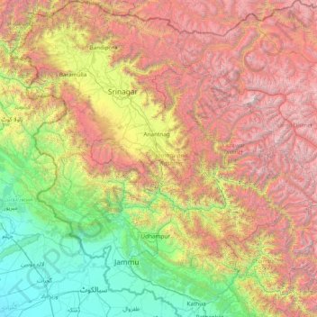
Nom : Carte topographique Jammu and Kashmir, altitude, relief.
Lieu : Jammu and Kashmir, India (32.27636 73.75003 34.78714 76.78032)
Altitude moyenne : 2’430 m
Altitude minimum : 208 m
Altitude maximum : 7’015 m
Jammu and Kashmir is home to several valleys such as the Kashmir Valley, Tawi Valley, Chenab Valley, Poonch Valley, Sind Valley, and Lidder Valley. The Kashmir valley is 100 km (62 mi) wide and 15,520.3 km2 (5,992.4 sq mi) in area. The Himalayas divide the Kashmir valley from the Tibetan plateau while the Pir Panjal range, which encloses the valley from the west and the south, separates it from the Punjab Plain of the Indo-Gangetic Plain. Along the northeastern flank of the Valley runs the main range of the Himalayas. This valley has an average height of 1,850 metres (6,070 ft) above sea-level, but the surrounding Pir Panjal range has an average elevation of 10,000 feet (3,000 m). The Jhelum River is the major Himalayan river which flows through the Kashmir valley. The southern Jammu region is mostly mountainous, with the Shivaliks, the middle and the great Himalayas running parallel to each other in a southeast-northwest direction. A narrow southwestern strip constitutes fertile plains. The Chenab, Tawi and Ravi are important rivers flowing through the Jammu region.
Autres cartes topographiques
Cliquez sur une carte pour visualiser sa topographie, son altitude et son relief.
Hyderabad
India > Telangana > Bahadurpura mandal
Hyderabad, Bahadurpura mandal, Hyderabad District, Telangana, India
Altitude moyenne : 549 m
Haraluru
India > Karnataka > Tumkur taluk
Haraluru, Tumkur taluk, Tumakuru District, Karnataka, India
Altitude moyenne : 864 m
Chennai
India > Tamil Nadu > Chennai
Chennai, Chennai District, Tamil Nadu, India
Altitude moyenne : 8 m
Mangaluru
India > Karnataka > Mangaluru taluk
Mangaluru, Mangaluru taluk, Dakshina Kannada District, Karnataka, 575001, India
Altitude moyenne : 25 m
Bengaluru
India > Karnataka > Bangalore North
Bengaluru, Bangalore North, Bengaluru Urban District, Karnataka, India
Altitude moyenne : 881 m
Noida
India > Uttar Pradesh > Dadri
Noida, Dadri, Gautam Buddha Nagar District, Uttar Pradesh, 201301, India
Altitude moyenne : 216 m
Pune
India > Maharashtra > Pune City > Pune
Pune, Pune City, Pune District, Maharashtra, 411001, India
Altitude moyenne : 641 m
Kadthal
India > Telangana > Soan mandal
Kadthal, Soan mandal, Nirmal District, Telangana, 504105, India
Altitude moyenne : 318 m
Pedda Arikatla
India > Andhra Pradesh > Konakanamitla
Pedda Arikatla, Konakanamitla, Prakasam, Andhra Pradesh, 523245, India
Altitude moyenne : 119 m
Ooty Lake
India > Tamil Nadu > Udhagamandalam > Udhagamandalam
Ooty Lake, Udhagamandalam, The Nilgiris District, Tamil Nadu, 643001, India
Altitude moyenne : 2’235 m
Delhi
India > Delhi > Kotwali Tehsil
Delhi, Kotwali Tehsil, Central Delhi, Delhi, 110006, India
Altitude moyenne : 216 m
Madurai
India > Tamil Nadu > Madurai
Madurai, Madurai South, Madurai district, Tamil Nadu, India
Altitude moyenne : 138 m
Kovilanchery
India > Tamil Nadu > Tambaram
Kovilanchery, Tambaram, Chengalpattu District, Tamil Nadu, 600126, India
Altitude moyenne : 11 m
Mandi
India > Himachal Pradesh > Mandi
Mandi, Mandi District, Himachal Pradesh, 175001, India
Altitude moyenne : 1’273 m
Anaikatti
India > Tamil Nadu > Coimbatore North
Anaikatti, Mannarkad, Palakkad District, Kerala, 678741, India
Altitude moyenne : 623 m
Bhikangaon
India > Madhya Pradesh > Bhikangaon Tahsil
Bhikangaon, Bhikangaon Tahsil, Khargone District, Madhya Pradesh, India
Altitude moyenne : 299 m
Hubli
India > Karnataka > Hubballi Urban Taluku
Hubli, Hubballi Urban Taluku, Dharwad District, Karnataka, 580020, India
Altitude moyenne : 626 m
Rishikesh
India > Uttarakhand > Rishikesh
Rishikesh, Dehradun, Uttarakhand, 249201, India
Altitude moyenne : 497 m
Bhopal
India > Madhya Pradesh > Huzur Tahsil
Bhopal, Huzur Tahsil, Bhopal District, Madhya Pradesh, 462001, India
Altitude moyenne : 498 m
Gaggal
India > Himachal Pradesh > Kangra
Gaggal, Kangra, Kangra District, Himachal Pradesh, 176209, India
Altitude moyenne : 755 m
Chandauli
India > Uttar Pradesh > Chandauli
Chandauli, Chandauli District, Uttar Pradesh, 232104, India
Altitude moyenne : 76 m
Basgo
India > Ladakh > Leh Tehsil
Basgo, Leh Tehsil, Leh District, Ladakh, India
Altitude moyenne : 3’367 m
Upshi
India > Ladakh > Leh Tehsil
Upshi, Leh Tehsil, Leh District, Ladakh, India
Altitude moyenne : 3’586 m
Babhnan
India > Uttar Pradesh > Harraiya
Babhnan, Harraiya, Basti District, Uttar Pradesh, India
Altitude moyenne : 94 m
Jite
India > Maharashtra > Mangaon
Jite, Mangaon, Raigad District, Maharashtra, India
Altitude moyenne : 191 m
Musi River
Musi River, Hyderabad, Uppal mandal, Medchal–Malkajgiri, Telangana, 5000036, India
Altitude moyenne : 490 m
Samethanahalli
India > Karnataka > Hosakote taluk
Samethanahalli, Hosakote taluk, Bengaluru Rural, Karnataka, 560117, India
Altitude moyenne : 868 m
Vairavanpatti
India > Tamil Nadu > Thiruppathur
Vairavanpatti, Thiruppathur, Sivagangai District, Tamil Nadu, 630207, India
Altitude moyenne : 103 m