
Carte topographique Kerala
Cliquez sur la carte pour afficher l’altitude.
À propos de cette carte
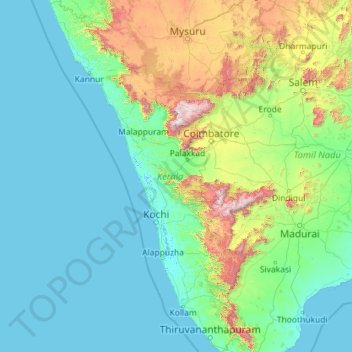
Nom : Carte topographique Kerala, altitude, relief.
Lieu : Kerala, Inde (8.29353 74.86407 12.79606 77.41236)
Altitude moyenne : 251 m
Altitude minimum : -4 m
Altitude maximum : 2’557 m
Autres cartes topographiques
Cliquez sur une carte pour visualiser sa topographie, son altitude et son relief.
Solan
Inde > Himachal Pradesh > Solan
Solan (en hindi : सोलन) est le siège du District de Solan (créé le 1er septembre 1972) dans l'État indien de l'Himachal Pradesh. La ville est située à 46 km (29 miles) au sud de Shimla, la capitale de l'État. À une altitude moyenne de 1 600 m, le lieu est nommé d'après la déesse hindoue Dourgā.
Altitude moyenne : 1’312 m
Mumbai
Bombay est située dans l'ouest de l'Inde, à l'embouchure du fleuve Ulhas, sur la côte occidentale du pays, appelée à cette latitude côte de Konkan. La ville, qui borde la mer d'Arabie, s'est développée sur l'île de Salsette, dont la partie nord appartient au district de Thane. L'altitude de la ville…
Altitude moyenne : 13 m
Pune
Inde > Maharashtra > Pune City Subdistrict
Pune se trouve à 120 km au sud-est de Bombay, à la confluence des rivières Mula et Mutha, sur le bord du plateau du Deccan dans la chaine des Ghats occidentaux, à 554 mètres d'altitude en moyenne. Le lac de retenue de Khadakwasla (en) au sud-ouest de la ville permet l'approvisionnement en eau.
Altitude moyenne : 641 m
Kangchenjunga
Inde > Sikkim > Chungthang
Le Kangchenjunga (appelé aussi Kanchenjunga, Kangchen Dzö-nga, Kachendzonga, Kintchindjinga ou Kangchanfanga) est un sommet de l'Himalaya, sur la frontière indo-népalaise, à l'est du Népal, entre le district de Taplejung et l'État indien du Sikkim où il peut être vu notamment de la capitale Gangtok.…
Altitude moyenne : 7’725 m
Delhi
Inde > Delhi > Kotwali Tehsil
L'arête de Delhi est un petit massif qui trouve son origine dans la chaîne des Aravalli et qui entoure les parties ouest, nord-est et nord-ouest de la ville. Elle atteint l'altitude de 318 m.
Altitude moyenne : 216 m
Kargil
Inde > Ladakh > Kargil tehsil
À une altitude moyenne de 2 676 mètres, la ville se situe au bord des rives du Suru.
Altitude moyenne : 3’262 m
Gangotri
Inde > Uttarakhand > Bhatwari
Le site comporte un temple dédié à la déesse Ganga, à plus de 3 000 mètres d'altitude que surplombe une montagne de 6 614 mètres. On y trouve des bassins consacrés aux trois divinités de la trimūrti, Brahmā, Vishnou et Shiva, dans lesquels se baignent les dévots hindous.
Altitude moyenne : 4’139 m
Dharamsala
Inde > Himachal Pradesh > Dharamshala
La ville s'étend sur 27,6 km2 à une altitude moyenne de 1 457 mètres. L'agglomération se divise en deux parties.
Altitude moyenne : 1’781 m
Udhagamandalam
Inde > Tamil Nadu > Udhagamandalam
Cette station climatique à 2 250 m d'altitude fut fondée au début du XIX siècle pour accueillir le gouvernement de Madras qui voulait prendre le frais en été. Auparavant, cette région était uniquement habitée par les Todas, peuple tribal vouant une adoration toute particulière aux buffles. La ville…
Altitude moyenne : 2’234 m
Mumbai
Bombay est située dans l'ouest de l'Inde, à l'embouchure du fleuve Ulhas, sur la côte occidentale du pays, appelée à cette latitude côte de Konkan. La ville, qui borde la mer d'Arabie, s'est développée sur l'île de Salsette, dont la partie nord appartient au district de Thane. L'altitude de la ville…
Altitude moyenne : 13 m
Bangalore
Inde > Karnataka > Bangalore North > Bangalore
Bangalore bénéficie d'un climat tropical de mousson avec une saison des pluies bien marquée. La ville jouit d'un climat moins étouffant que la majeure partie des villes indiennes en raison de son altitude assez élevée. Cependant des vagues de forte chaleur ne sont pas à exclure. Le mois le plus froid…
Altitude moyenne : 879 m
Kaza
Inde > Himachal Pradesh > Spiti
La ville de Kaza, Kaze ou Kaja est une subdivision de la vallée de Spiti dans le district de Lahaul et Spiti dans l’État de l'Himachal Pradesh, dans l'Ouest de l'Himalaya en Inde. Spiti, qui est une partie du district de Lahaul et Spiti dans l'Himachal, est une région froide de haute altitude ayant…
Altitude moyenne : 4’161 m
Dharamsala
Inde > Himachal Pradesh > Dharamshala
La ville s'étend sur 27,6 km2 à une altitude moyenne de 1 457 mètres. L'agglomération se divise en deux parties.
Altitude moyenne : 1’781 m