
Carte topographique Spencer
Carte interactive
Cliquez sur la carte pour afficher l’altitude.
À propos de cette carte
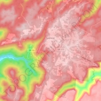
Nom : Carte topographique Spencer, altitude, relief.
Altitude moyenne : 496 m
Altitude minimum : 277 m
Altitude maximum : 564 m
Spencer is topographically isolated by the Cumberland Plateau's escarpment to the north and west, the Cane Creek Valley to the east, and the Dry Fork Gulf to the south. Cane Creek, along with its tributary, Dry Fork, slices a narrow valley as it spills down northward toward its confluence with the Caney Fork, effectively dividing the Spencer area from the rest of the plateau. Cane Creek's upper watershed, known for its scenic waterfalls and geological formations, comprises the bulk of Fall Creek Falls State Park.
Autres cartes topographiques
Cliquez sur une carte pour visualiser sa topographie, son altitude et son relief.
Fall Creek Falls State Park
United States > Tennessee > Van Buren County
Fall Creek Falls State Park, Van Buren County, Tennessee, United States
Altitude moyenne : 524 m
Welchland
United States > Tennessee > Van Buren County
Welchland, Van Buren County, Tennessee, United States
Altitude moyenne : 542 m