
Faire un don
Équipez-vous pour votre prochaine aventure :
En tant que Partenaire Amazon, ce site perçoit une commission sur les achats éligibles sans surcoût pour vous.
Carte topographique Church Hanborough
Cliquez sur la carte pour afficher l’altitude.
Faire un don
Équipez-vous pour votre prochaine aventure :
En tant que Partenaire Amazon, ce site perçoit une commission sur les achats éligibles sans surcoût pour vous.
À propos de cette carte
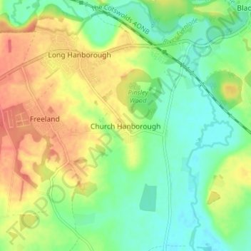
Nom : Carte topographique Church Hanborough, altitude, relief.
Altitude moyenne : 85 m
Altitude minimum : 61 m
Altitude maximum : 115 m
Faire un don
Équipez-vous pour votre prochaine aventure :
En tant que Partenaire Amazon, ce site perçoit une commission sur les achats éligibles sans surcoût pour vous.
Autres cartes topographiques
Cliquez sur une carte pour visualiser sa topographie, son altitude et son relief.
Faire un don
Équipez-vous pour votre prochaine aventure :
En tant que Partenaire Amazon, ce site perçoit une commission sur les achats éligibles sans surcoût pour vous.
Faire un don
Équipez-vous pour votre prochaine aventure :
En tant que Partenaire Amazon, ce site perçoit une commission sur les achats éligibles sans surcoût pour vous.
Hanborough
United Kingdom > England > Oxfordshire > West Oxfordshire > Church Hanborough
Altitude moyenne : 83 m
Faire un don
Équipez-vous pour votre prochaine aventure :
En tant que Partenaire Amazon, ce site perçoit une commission sur les achats éligibles sans surcoût pour vous.
Faire un don
Équipez-vous pour votre prochaine aventure :
En tant que Partenaire Amazon, ce site perçoit une commission sur les achats éligibles sans surcoût pour vous.
Cassington
United Kingdom > England > Oxfordshire > West Oxfordshire > Cassington
Altitude moyenne : 72 m
Faire un don
Équipez-vous pour votre prochaine aventure :
En tant que Partenaire Amazon, ce site perçoit une commission sur les achats éligibles sans surcoût pour vous.
Faire un don
Équipez-vous pour votre prochaine aventure :
En tant que Partenaire Amazon, ce site perçoit une commission sur les achats éligibles sans surcoût pour vous.
Faire un don
Équipez-vous pour votre prochaine aventure :
En tant que Partenaire Amazon, ce site perçoit une commission sur les achats éligibles sans surcoût pour vous.
Great Park
United Kingdom > England > Oxfordshire > West Oxfordshire > Long Hanborough
Altitude moyenne : 94 m
Glympton
United Kingdom > England > Oxfordshire > West Oxfordshire > Glympton
Altitude moyenne : 123 m
Great Tew
United Kingdom > England > Oxfordshire > West Oxfordshire > Great Tew
Altitude moyenne : 157 m
Faire un don
Équipez-vous pour votre prochaine aventure :
En tant que Partenaire Amazon, ce site perçoit une commission sur les achats éligibles sans surcoût pour vous.
Faire un don
Équipez-vous pour votre prochaine aventure :
En tant que Partenaire Amazon, ce site perçoit une commission sur les achats éligibles sans surcoût pour vous.
Milton-under-Wychwood
United Kingdom > England > Oxfordshire > West Oxfordshire
Altitude moyenne : 148 m
Ascott-under-Wychwood
United Kingdom > England > Oxfordshire > West Oxfordshire
Altitude moyenne : 127 m
Stanton Harcourt
United Kingdom > England > Oxfordshire > West Oxfordshire > Stanton Harcourt
Altitude moyenne : 67 m
Faire un don
Équipez-vous pour votre prochaine aventure :
En tant que Partenaire Amazon, ce site perçoit une commission sur les achats éligibles sans surcoût pour vous.
North Leigh
United Kingdom > England > Oxfordshire > West Oxfordshire > North Leigh
Altitude moyenne : 108 m
Faire un don
Équipez-vous pour votre prochaine aventure :
En tant que Partenaire Amazon, ce site perçoit une commission sur les achats éligibles sans surcoût pour vous.
Faire un don
Équipez-vous pour votre prochaine aventure :
En tant que Partenaire Amazon, ce site perçoit une commission sur les achats éligibles sans surcoût pour vous.
Minster Lovell
United Kingdom > England > Oxfordshire > West Oxfordshire > Minster Lovell
Altitude moyenne : 112 m
Faire un don
Équipez-vous pour votre prochaine aventure :
En tant que Partenaire Amazon, ce site perçoit une commission sur les achats éligibles sans surcoût pour vous.
Heythrop
United Kingdom > England > Oxfordshire > West Oxfordshire > Heythrop
Altitude moyenne : 195 m
Faire un don
Équipez-vous pour votre prochaine aventure :
En tant que Partenaire Amazon, ce site perçoit une commission sur les achats éligibles sans surcoût pour vous.
Little Faringdon
United Kingdom > England > Oxfordshire > West Oxfordshire > Little Faringdon
Altitude moyenne : 80 m
South Leigh
United Kingdom > England > Oxfordshire > West Oxfordshire > South Leigh
Altitude moyenne : 80 m
Faire un don
Équipez-vous pour votre prochaine aventure :
En tant que Partenaire Amazon, ce site perçoit une commission sur les achats éligibles sans surcoût pour vous.
Faire un don
Équipez-vous pour votre prochaine aventure :
En tant que Partenaire Amazon, ce site perçoit une commission sur les achats éligibles sans surcoût pour vous.
Faire un don
Équipez-vous pour votre prochaine aventure :
En tant que Partenaire Amazon, ce site perçoit une commission sur les achats éligibles sans surcoût pour vous.
Faire un don
Équipez-vous pour votre prochaine aventure :
En tant que Partenaire Amazon, ce site perçoit une commission sur les achats éligibles sans surcoût pour vous.