
Carte topographique Fawler
Cliquez sur la carte pour afficher l’altitude.
À propos de cette carte
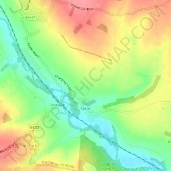
Nom : Carte topographique Fawler, altitude, relief.
Lieu : Fawler, West Oxfordshire, Oxfordshire, England, United Kingdom (51.84207 -1.47602 51.86836 -1.43344)
Altitude moyenne : 117 m
Altitude minimum : 77 m
Altitude maximum : 158 m
Autres cartes topographiques
Cliquez sur une carte pour visualiser sa topographie, son altitude et son relief.
Ledwell
United Kingdom > England > Oxfordshire > West Oxfordshire > Sandford St. Martin
Altitude moyenne : 142 m
Eynsham Mill
United Kingdom > England > Oxfordshire > West Oxfordshire > Eynsham
Altitude moyenne : 71 m
Shipton-under-Wychwood
United Kingdom > England > Oxfordshire > West Oxfordshire
Altitude moyenne : 131 m
Great Park
United Kingdom > England > Oxfordshire > West Oxfordshire > Long Hanborough
Altitude moyenne : 94 m
Upper Milton
United Kingdom > England > Oxfordshire > West Oxfordshire > Milton-under-Wychwood
Altitude moyenne : 153 m