
Carte topographique Magothy River
Carte interactive
Cliquez sur la carte pour afficher l’altitude.
À propos de cette carte
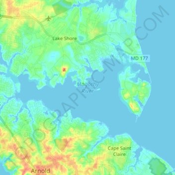
Nom : Carte topographique Magothy River, altitude, relief.
Altitude moyenne : 9 m
Altitude minimum : -3 m
Altitude maximum : 46 m
Almost all of the creeks and tidal coves on the Magothy are named, partly as the result of a project started in 2001 by the Magothy River Association. They are shown on a map produced as part of that project, and the major ones are shown on the USGS topographic map.
Autres cartes topographiques
Cliquez sur une carte pour visualiser sa topographie, son altitude et son relief.
Magothy Forest
United States > Maryland > Anne Arundel County > Severna Park
Magothy Forest, Severna Park, Anne Arundel County, Maryland, 21146, United States
Altitude moyenne : 13 m
Longmeadow North
United States > Maryland > Anne Arundel County > Severna Park
Longmeadow North, Severna Park, Anne Arundel County, Maryland, 21146, United States
Altitude moyenne : 8 m
Linstead-on-the-Severn
United States > Maryland > Anne Arundel County > Severna Park
Linstead-on-the-Severn, Severna Park, Anne Arundel County, Maryland, 21146, United States
Altitude moyenne : 11 m
Severndale
United States > Maryland > Anne Arundel County > Severna Park > Severndale
Severndale, Severna Park, Anne Arundel County, Maryland, 22146, United States
Altitude moyenne : 18 m
Windrush Farm
United States > Maryland > Anne Arundel County > Severna Park > Windrush Farm
Windrush Farm, Severna Park, Anne Arundel County, Maryland, 21012, United States
Altitude moyenne : 10 m
Lower Magothy Beach
United States > Maryland > Anne Arundel County > Severna Park > Lower Magothy Beach
Lower Magothy Beach, Severna Park, Anne Arundel County, Maryland, 21122, United States
Altitude moyenne : 9 m