
Carte topographique Linstead-on-the-Severn
Carte interactive
Cliquez sur la carte pour afficher l’altitude.
À propos de cette carte
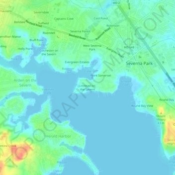
Nom : Carte topographique Linstead-on-the-Severn, altitude, relief.
Altitude moyenne : 11 m
Altitude minimum : -4 m
Altitude maximum : 49 m
Autres cartes topographiques
Cliquez sur une carte pour visualiser sa topographie, son altitude et son relief.
Magothy Forest
United States > Maryland > Anne Arundel County > Severna Park
Magothy Forest, Severna Park, Anne Arundel County, Maryland, 21146, United States
Altitude moyenne : 13 m
Longmeadow North
United States > Maryland > Anne Arundel County > Severna Park
Longmeadow North, Severna Park, Anne Arundel County, Maryland, 21146, United States
Altitude moyenne : 8 m
Magothy River
United States > Maryland > Anne Arundel County > Severna Park
Magothy River, Severna Park, Anne Arundel County, Maryland, United States
Altitude moyenne : 9 m
Severndale
United States > Maryland > Anne Arundel County > Severna Park > Severndale
Severndale, Severna Park, Anne Arundel County, Maryland, 22146, United States
Altitude moyenne : 18 m
Windrush Farm
United States > Maryland > Anne Arundel County > Severna Park > Windrush Farm
Windrush Farm, Severna Park, Anne Arundel County, Maryland, 21012, United States
Altitude moyenne : 10 m
Lower Magothy Beach
United States > Maryland > Anne Arundel County > Severna Park > Lower Magothy Beach
Lower Magothy Beach, Severna Park, Anne Arundel County, Maryland, 21122, United States
Altitude moyenne : 9 m