
Carte topographique Victor
Carte interactive
Cliquez sur la carte pour afficher l’altitude.
À propos de cette carte
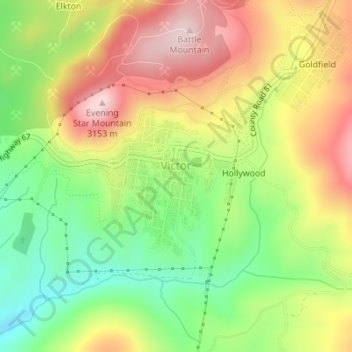
Nom : Carte topographique Victor, altitude, relief.
Lieu : Victor, Teller County, Colorado, United States (38.70404 -105.14716 38.71428 -105.13556)
Altitude moyenne : 2’974 m
Altitude minimum : 2’803 m
Altitude maximum : 3’160 m
In 2022, youtubers The Baseball Bat Bros attempted to break the Guinness World Record for Longest home run hit, set by Babe Ruth in 1921 with a verified measurement of 575 feet. The attempt was made at The Gold Bowl baseball and soccer field. Victor, having one of the highest elevations in the United States was an ideal location as thinner air at high elevations creates less drag on a traveling baseball than at lower elevations, thus allowing it to travel farther in the air. Various high school, college, and former professional baseball players were invited to attempt to break the record but none were successful with elevated land beyond the outfield and unfavorable winds likely spoiling the attempts. The longest home run hit on the day was an estimated 534 feet.
Autres cartes topographiques
Cliquez sur une carte pour visualiser sa topographie, son altitude et son relief.
Woodland Park
United States > Colorado > Teller County
Woodland Park, Teller County, Colorado, 80863, United States
Altitude moyenne : 2’652 m
Midland
United States > Colorado > Teller County
Midland, Teller County, Colorado, United States
Altitude moyenne : 2’874 m
Cripple Creek
United States > Colorado > Teller County
Cripple Creek, Teller County, Colorado, United States
Altitude moyenne : 2’946 m
Florissant
United States > Colorado > Teller County
Florissant, Teller County, Colorado, United States
Altitude moyenne : 2’556 m
Divide
United States > Colorado > Teller County
Divide, Teller County, Colorado, United States
Altitude moyenne : 2’796 m
Woodland Park
United States > Colorado > Teller County > Woodland Park
Woodland Park, Teller County, Colorado, 80863, United States
Altitude moyenne : 2’657 m
Copper Mountain
United States > Colorado > Teller County
Copper Mountain, Teller County, Colorado, 80813, United States
Altitude moyenne : 2’946 m
Squaw Mountain
United States > Colorado > Teller County
Squaw Mountain, Teller County, Colorado, 80860, United States
Altitude moyenne : 2’977 m