
Carte topographique Cascade Locks
Carte interactive
Cliquez sur la carte pour afficher l’altitude.
À propos de cette carte
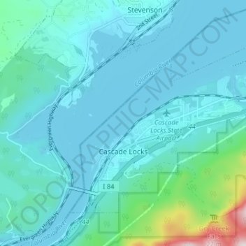
Nom : Carte topographique Cascade Locks, altitude, relief.
Lieu : Cascade Locks, Hood River County, Oregon, United States (45.65829 -121.90445 45.69097 -121.84013)
Altitude moyenne : 101 m
Altitude minimum : 18 m
Altitude maximum : 701 m
Autres cartes topographiques
Cliquez sur une carte pour visualiser sa topographie, son altitude et son relief.
Hood River
United States > Oregon > Hood River County
Hood River, Hood River County, Oregon, United States
Altitude moyenne : 112 m
Parkdale
United States > Oregon > Hood River County > Parkdale
Parkdale, Hood River County, Oregon, United States
Altitude moyenne : 538 m
Odell
United States > Oregon > Hood River County
Odell, Hood River County, Oregon, United States
Altitude moyenne : 244 m
Badger Lake Dam
United States > Oregon > Hood River County
Badger Lake Dam, Hood River County, Oregon, United States
Altitude moyenne : 1’565 m
Government Cove
United States > Oregon > Hood River County > Cascade Locks
Government Cove, Cascade Locks, Hood River County, Oregon, United States
Altitude moyenne : 89 m
Cascade Locks Marine Park
United States > Oregon > Hood River County > Cascade Locks
Cascade Locks Marine Park, Cascade Locks, Hood River County, Oregon, United States
Altitude moyenne : 72 m
Mount Hood
United States > Oregon > Hood River County
Mount Hood, Hood River County, Oregon, United States
Altitude moyenne : 2’716 m
Dee
United States > Oregon > Hood River County
Dee, Hood River County, Oregon, United States
Altitude moyenne : 424 m
Columbia River
United States > Oregon > Hood River County > Cascade Locks
Columbia River, Cascade Locks, Hood River County, Oregon, United States
Altitude moyenne : 543 m
Shellrock Spring
United States > Oregon > Hood River County
Shellrock Spring, Forest Road 17, Hood River County, Oregon, United States
Altitude moyenne : 1’157 m